After 4 years and 10 months away sailing around the world we are back in our new home in Comox on Vancouver Island. We lucked out getting a spot in the marina for our boat. We are now busy emptying our storage locker into our house, buying a new car and removing stuff off the boat. It's all a bit much, maybe should have stayed out cruising, but it is nice to be home. At the same time we are doing some hiking and kayaking with friends here.
Tagish is now sold. On to new adventures. This blog may be reactivated at some point.
-
Monday, July 28, 2014
Monday, July 14, 2014
Almost Home
From Neah Bay we spent the next night at Esquimalt where air temp finally was warming for our tropic bodies. Next night on to Victoria, motoring no wind. Treated ourselves to an expensive marina there. Got some shopping done and cell phone activated. Email us for #.
Spent next night at Prevost island anchored, and last night anchored at Nanaimo.
Hope to be in Comox in two days.
Spent next night at Prevost island anchored, and last night anchored at Nanaimo.
Hope to be in Comox in two days.
Wednesday, July 9, 2014
Hawaii to Vancouver
June 11 we left Honolulu for Hanalei bay on north side of Kuai. We stopped at Ko Olina Basin for some diesel first, which is a few miles west of Honolulu. We had little wind until we got to the NW corner of Oahu and then 20 to 25 knots from the East hit us, giving us maybe 30 seconds warning, though we could see it coming on the water.
It was a vigorous overnight sail and we arrived the next morning and anchored in an attractive bay. We spent two days here exploring and getting our last walks in and a few more groceries for the long passage ahead of us.
At July 14 7am we were off for home, 2600 miles to NE. The theory is to head due North to get around the North Pacific High that forms in summer. Then, when you pickup the N westerlies turn and head to the Juan de Fuca Strait.
We have a new toy on the boat, an Ipad, and we put a app on it called HF Fax which gives us good weather faxes by sitting it next to our HF radio. We have no pactor modem or other source of weather except the high seas forecast which is also broadcast on the HF radio. These weather faxes shows the positions of the highs and lows. There did seem to be a good solid high forming when we left, but later it would form then break up and reform. I believe it is suppose to block the gales that come across the Pacific.
After 45 minutes of motoring to clear the land our wind started. Soon we had 3 reefs in the main in the strong E winds. This first day of our passage turned out to be the best as far as mileage made as we had steady strong wind on the beam. The wind soon came more N East which slowed us down and made us drift off to the west a bit, which is okay. We would get a few small squalls every evening just to keep us on our toes. We are still loosing ground slowly to the West due to the ENE winds, good sailing though.
June 19 winds getting lighter now, sometimes down to 7 knots and then back up to 15. By the 21st of June we are motoring at 33deg North. We motored for 30 hours and by mid morning the next day we got our first NW winds of about 12 knots. This is good, we are lucky to get the NW wind this far south. The weather fax shows the high is split with a ridge between them at 33N. By dark the NW winds are up and we have 2 reefs in the main, but we are on course for home.
The next couple days are good sailing, though very rough seas for the first day, which gradually eased up to smoother sailing. The weather fax now shows a large gale coming across the Pacific just above us at about 40deg N. We changed our sails to wing and wing so as not to go North so fast and head more East to allow this gale to go by above us. It has been slowly getting colder and we now have all our warm clothes on. Since we got the NW winds we have had no more squalls, but the sky is much more overcast.
We have been in radio contact with two other yachts, at 8pm every night we would take each others positions and see what weather they have and if any problems. Sanddollar with a family of 5 on board, was 3 days ahead of us so it was interesting to see what weather they were getting. The other yacht True Blue was a few days behind us with Alice and two crew aboard. We first met Alice in South Africa as she blazed around the world in 14 months
The next day the wind got up to 23 to 30 knots and large rough seas as the gale above us went by. We must have got the outer edge of it.
Officially gale force starts at 34 knots. Had a rough and windy night with 3 reefs in main. By the following day things were easing and we were soon back to 1 reef in main and nice sailing. Much colder now, we spend most of our time inside the boat with the door closed and the wind vane steering, we just go out for a quick look every half hour. The AIS alarm will tell us if any ships are nearby. June 28 wind died and we are now sailing at about 1.5knots. We used this opportunity to clean up a bit and baked some bread. I noticed a line trailing about 6 ft from the back of the boat. I grabbed it with the boat hook and pulled the end up to my hands, but could not pull it off it was stuck on prop. We must of snagged it some where along the way, it was not one of our ropes. I started the engine and briefly put engine in gear, prop turned but I could tell it had some resistance. I went in reverse and forward a few times and line disappeared but still not feel right. Since it was somewhat calm out I put on my wet suit and went off the back of the boat with a knife and had a look but the rope was now gone and all looked okay. So back on board I tried the engine again and everything was okay. That is cold water.
The AIS alarm went off early evening, meaning we had a ship that was going to pass any where from 0 to 1 mile of distance from us. The AIS told us this while ship was 12 miles away. We were only sailing at 1 to 2 knots so I called him up on radio and he said he would miss us and that he did going by us by about a mile. We then motored for about 4 hours and then the wind picked up and by 10pm was 25 to 30 knots and for about 30 minutes kicked up to almost 35 knots. Don't know where that came from. By late in night wind eased and we got heavy rain and still raining in the morning in a 15 knot SE wind. Now at 41deg N and 146deg W. Still getting nice clear weather faxes on our Ipad. They show we may be getting hit by a gale that we can see tracking across Pacific only a couple days behind the previous gale that just went by. What's going on, not suppose to be getting all these gales this time of year?
This gale was hard to track on the weather faxes as it seemed to move around a bit and then kind of took us by surprise as it expanded and nailed us. By 11pm June 30 we had a gale blowing out of the SW. We had 3 reefs in main as it built and then put the tiny 4th and last reef in and no head sail. We were still going 6 to 8 knots. So I put out our car tire we have been carrying since I bought it in Sri Lanka for the Indian Ocean. I had been wanting to try it ever since I bought it. Well it works, it slowed us by a knot or 2 and helped guard against a bad knock down. The waves were getting gigantic now with huge breaking crests. After another hour or 2 we were getting up to 8 and 9 knots of boat speed as wind increased and this was steady speed not surges. So I figured this was time for a real drogue and got out our gale rider. I managed to pull up the tire between surges up close to the boat and left it and throw over the Gale Rider and let out about 60 feet of our 300ft line. This slowed us down to 4 to 5 knots, much better. I am not sure how strong wind got as we have no wind instruments. But It was over 40 knots for a quite a while, you could see wave tops being blown off and streaks of foam. Then eased to a steady 35 to 40 knots later.
Shortly after putting out the Gale Rider we had a small drama through my own mistake. We had the genoa rolled in except for about a 3ft tab that out to the end of our running pole which was still in place. The tab was sticking out to front with pole, not to side. I noticed it was starting to vibrate quite a bit and shake the forestay. I should have left it but decided to remove pole and roll in genoa. I got the pole off as the boat gyrated all over the place. Then we tryed to roll in genoa and it would not budge, then I noticed there was no rope left on the drum because it had been rolled so tight as we rolled it up in the high winds. It was a new genoa and I guess I did not but enough rope on the drum for a tight genoa. So now I had to pull the furling line to bow and wrap about 4 turns around the drum which is easy to do on ours normally but the conditions made it difficult. But by the time I got all this done the 3ft genoa tab was flogging away and got the sheets tangled and also the wind loosened up the genoa and more of it started to come out and soon almost half the genoa was out and flogging like crazy and fore-stay was shaking badly. Big trouble now. I now had the furling line sorted okay but we could not role in the genoa as the sheets were twisted around it. I had to pull both sheets back to the bow and they whipped around like banshees threatening to take my head off. I managed to get them under control and do several wraps around the forestay to untangle them and then they were okay and I had to bring them both up the lee side of boat and sheet them together on the winch as they were all tangled up. but we managed to finally roll the genoa back in after unrolling it a couple of turns to get it straight. We got all the genoa back in except for about 4 ft of it. and sheeted it as you would if sailing. We did not need any more sail out but nothing we could do and the drogue keep us an good speeds.
The reason we could not roll all the genoa in is because while half the genoa was out flogging I thought it might break the forestay, so I had moved our spinaker halyard foreward for support if fore-stay broke. So when I rolled genoa back it I forgot about the spinnaker halyard and it got wrapped inside the genoa and made it so we could not roll it all the way in. We managed to get this untangled the next day when wind eased.
The conditions were the worst we have seen on our trip around the world. By midnight the wind started to ease, so it was a 24 hour gale and we had the drogue out for over 10 hours of that. At first light we pulled in the drogue. Retrieving the Gale Rider was not too difficult. I pulled it in by hand, by pulling in about a foot every time the boat surged back as a wave passed. I always got overrides if I used a winch. Just had to watch your fingers on the cleat. Wind was about 25 knots and slowly dropped to 15 during the morning. We were both very tired as had not got much sleep and the easy conditions were welcomed.
We had a couple of good days with the wind up and down and a few hours of motoring. Then the next gale got us, we could see it coming on the weather fax but not much we could do as were too far North now. We are at 44N and 138W and as usually happens it started just after dark so it is hard to see the seas. We put in the 4th reef about midnight as the wind got up to 35 knots. This gale was not nearly as bad as the first one with winds 30 to 35 approx and only lasted 12 hours. Now back to good sailing in brisk winds. Only 400 miles to the Juan De Fuca strait. Next day was very foggy and we used the radar every half hour to look out 20 miles around us. Conditions are pretty good, getting more sun now and winds up and down.
The high seas forecast says there will be a gale 60 to 200 miles off Cape Flattery about 12 hours after we hope to arrive there. So we are putting the peddle to the metal to beat it. We are feeling upbeat as things are looking good and we are almost home.
We almost ran over a whale this afternoon, just missed him by a few feet. We saw several more humpback whales, what a thrill to see one of them spy hopping. Later a large pod of dolphins came by to follow along for a bit, I always think of them as a good luck symbol.
One day to go and the wind is 22 to 27 knots and we are pushing the boat hard, just flying along often at 7 and 8 knots. We can now see the mountains on Vancouver Island Then as it gets dark can see a light off Cape Flattery. The wind dies with about 10 miles to go and we have to motor. My tide table on electronic chart says we will get there near maximum ebb of tide, darn. Late at night we enter the Juan De Fuca strait and soon the ebbing tide slows us down to 2 knots. The swells steepen as they meet the out going tide. Finally, there is Neah Bay and we pull into the well protected harbor and drop anchor at 8am local time. Our boat has been on Hawaii time until now (3 hours with daylight savings). Our Voyage is over and it's a strange feeling. It as taken us 4 years and 10 months to sail around the world. Its been a great adventuer and now it is time to move on to other things.
We took the dinghy to shore to phone customs for clearance and then stretched out our legs around the small town. Will continue on tomorrow for home.
INFO
- Kuai anchored at 22 12.647N 159 30.134W in 42 feet. took dinghy up river on east side of bay and left on beach with boat trailers.
-In Hawaii when we cleared in they gave us a cruising permit and they said in was good for any US waters. When we arrived in Neah bay we phoned customs and gave them the cruising permit # and we were done. We had to borrow the marina gals cell phone for the call as could not find a pay phone.
-Anchorage in Neah Bay, anchored int 38ft at 48 22.30N 124 36.87W
Sunday, June 8, 2014


.jpg)

Friday, June 6, 2014
Time to leave for Home
Our new Genoa came in last week and has been installed, it looks good. Our new mainsail came in by UPS from Thailand yesterday and we installed it this morning, it fit perfectly, all good to go. We are pleased with the speedy service.
We have done a couple of hikes on the island. Then we both got a cold with lots of coughing. This seems to be going around as we have seen a number of people with this. This set us back a couple of days. There are a couple of nice beaches here to walk on and watch the surfers.
We are almost ready to leave and will probably leave next Wed or Thur for Kuai where we will spend a couple of days and then we will leave for the 2500 mile passage to the mainland. Depending on where we end up on the coast we may make our first stop at Neah bay at entrance to Juan de Fuca strait. Then possibly a night at Sooke and then clear in at South Pender island. Then it will be a couple more days up to Comox our new home. So it will be roughly 25 days for the passage or up to 30 if really slow then about 5 days up to Comox. Will try update when arrive at Neah bay or Pender Island.
Saturday, May 10, 2014
Arrived Honolulu
We left Nuka Hiva April 11 bound for Honolulu 2300 miles to the NW. There was little wind as we headed up the lee side of the island, and we motored most of the way up. As we cleared the island the wind came at us just forward of the beam at about 22 to 26 knots the rest of the day. Tagish had 2 reefs in the main and a third of the genoa out and our staysail up. We like to use the staysail when the wind is forward of the beam.
The next 3 days were similar with winds occasionally to 30 knots, good but vigorous sailing , making great progress North. We are trying to stay on the 140 deg of longitude so as not to lose any of our easting to make for a easier time of it when we get into the NE trades above the equator. By April 14 as we neared the equator the wind was easing and becoming more fit full though with still some good sailing. A large pod of dolphins swam with us for a half hour today. Had a few squalls go by with winds to 30 knots.
April 15 we watched a
full lunar eclipse during the night. the moon became a coppery color and it got much darker outside. The eclipse lasted over an hour and then the moon slowly became uncovered. It was amazing that we saw it as we have had so much cloudy and squally weather.
After a night of squalls and rolling the genoa in and out many times, the genoa finally gave up. A big squall came up fast after dark when it's hard to see them coming. We were a bit slow getting the genoa in and that little bit of flogging in the strong winds was enough to tear the old sail right along the edge of the suncover. The clew tore out, making a 35 foot rip up one edge of the sail and a 2 foot rip along the foot. This sail was 7 years old and took us around the world so it did us pretty good, though I had hoped it would get us home. This was serious, we had just lost half our sail power and we were only 400 miles into a 2300 mile passage. The damage would be very difficult to repair as there is a huge strain on the clew where the lines are attached. Also not sure if we would even have enough repair material to sew such a huge rip. The other option was to cut off all the damage and put a big knot for a new clew in the corner and use sail in light winds. We would decide if we got desperate. No wasting food now, save everything.
The next day and night was squalls every hour or so and lots of rain, really crappy weather. Our staysail is now our main headsail and due to the constant squalls we just left 2 reefs in the main. We are now very close to the equator and motoring off and on to keep boat moving and get further north and into NE trades which we hoped to pickup by 5 deg N. April 17 the squalls have stopped for now but winds very light. Sailing slowly or motoring. Late the next day we entered a dark wall of clouds that extended in both directions as far as you could see, this at about 2 deg N now. The rain then started, but only 10 knots of wind, still motoring off and on.
We got a call on the VHF radio from a Japanese long liner fishing about 10 miles away. He could see us on his radar he said, which amazed me as there was so much rain clutter. He asked us not to go west of 140 deg as there was two boats fishing with long lines. Still little wind and our poor main sail is banging more than ever as there is a big swell running now. We woke up one morning to find our 2 year old mainsail had developed a 3 foot vertical split in the belly of the sail, between the 1st and 2nd reef points. We could still use it but would have to be very careful.
The next day we only did 65 miles as a light north wind came up right on the nose, to slow us even more. Then almost right on 5 deg N a light NE wind developed, finally this is what we were waiting for. In this area of the Pacific, you can often almost sail right through the doldrums, but we hit it bad and the doldrums seemed to go on for ever. Not sure how much of what we had was doldrums and how much was just bad weather. The next day or so it stayed cloudy, but we had enough wind to sail and occasionally very brisk winds that moved us along nicely. Still lots of rain and squalls with winds around 25 knots. Next evening had a gale that blew for about 10 hours with 30 to 40 knots. Only had 3rd reef in main and our small staysail up. Still getting squalls after this ended with winds 35 to 40 knots. At least we don't have to keep rolling our headsail in and out as we no longer have one. Then more gale force winds most of next night. Had 3rd reef in main for almost 3 days. This has been our 6th equator crossing and definitely our worst.
April 25. The sun is out finally and no squalls lurking. Winds are NE 30 plus knots. But that's good we are moving and don't need a headsail. staysail and reefed main work great. But seas are big and rough so life is pretty basic on the boat now as hard to move around. Next couple of days are similar and some times it would blow so hard we would have to help the self steering as would round up into the wind during strong gusts, don't know what windspeed got up to sometimes. We tried to repair our mainsail one day, but it was difficult in the rough conditions and the repair came undone.
When wind eases we would put up the storm jib. Since we had no genoa now we had removed it off the roller furler a few days ago during a calm period. I tied a number of small piece of rope loosely around the roller furler foil, enough for ever 2nd hank on the storm jib and we hoisted the storm jib up the foil. This worked amazingly well, maybe because of the slot effect with the staysail, but anytime we put it up our speed would pickup by about a knot, it pulled like a trooper.
The weather is still pleasant on April 28, and 29 we have the 3rd reef out finally and back to the 2nd reef and where we will leave it due to the rip in first reef. The strong winds have allowed us to make several days of over a 100 miles. We are slowing now with about 450 miles to go. Did a 87 mile day and a 67 mile day, we are missing our genoa. When winds got real light we risked taking the 2nd reef out up to the 1st reef. Weather still nice did a 107 mile day in better winds.
The wind died almost completely with 130 miles left, so we started the engine for the first time in a long time. Then the winds went dead calm later. Ended up motoring the rest of the way to Honolulu. It was a welcome sight as we approached the entrance and motored into Ala Wai boat basin. I tied up on the old fuel dock and checked with the Hawaii yacht club for moorage and they said we could stay for a few days. Then we could move into Ala Wai marina. Arrived May 6 8am- 25 days at sea.
INFO
- We phoned custom from a courtesy phone at HYC and they came out to boat and later we had to go to there office to pay a $19 fee and finish process. A quarantine officer also came out to boat.
-Waypoint for our dock in Hawaii Yacht club. 21 17.17N 157 50.55W and entrance wp to Boat basin
is 21 16.55N 157 50.79W
-We moved later to Ala Wai marina rite beside HYC but they want to do a inspection first and also you must to a run out of the harbor to a buoy and back to show your engine works. This place is the most buerocratice marina in the world that I have seen. The inspection checks for coast guard saftey things, epirbs. They ask what is horsepower of engine, weird, just to stay in the marina. You initial every rule on a peice of paper to show you have read them all. But everyone is friendly, the HYC is very friendly and nice place to stay.
Friday, April 11, 2014
Nuka Hiva
After 3 days at Ua Pou the Arc rally boats left and we had the anchorage all to ourselfs. After a couple days a lone boat came in. This is a beatuiful quiet island, every day you see a few locals out in the bay paddling their canoes around the bay and sometimes playing in the surf.
After 5 days here it was time to leave. I spent part of the day scrapping of the goose neck barnacles from our last passage. The next morning we upped anchor and left for Nuka Hiva 25 miles to the North. We had a brisk sail in a 25 to 30 knot East wind. It was a beam wind but do to the cross current we had to aim a bit hight of course, so wind was just forward of beam and he spray was flying occasionally. We figured this was a warm up for the passage to Hawaii. After half way there the wind eased to 20 knots or so and we let out a bit more sail.
We dropped anchor in the late afternoon in the large bay of the main town. It is a bigger and more lively place than Ua Pou, more traffic on roads and not as peaceful. About 15 boats here in the large anchorage.
After a few days here we are off to Oahu Hawaii.
INFO
-Anchored in 38ft at 08 54.94S 140 05.91W Anchorage is somewhat rolly as the swell comes into the bay. But holding is good.
- As at Ua Pou they have a public tap with drinking water. There are taps by dinghy dock, but they are only good for laundry etc. The potable water taps are at far end of town by bridge in a big parking area, a 10 or 15 minute walk.
-We bought diesel at the gas station by the main dock where the supply ship comes in. We jerry canned with the dinghy, as it is a difficult dock to bring a yacht along side, not yacht friendly at all. A catamarran we talked to backed in between two of the huge bumpers. Price of diesel was 165 francs a liter, very expensie. You could get a duty free form from the yacht services people on dinghy dock area, but would only be worth while if you bought more than 300 liters of fuel, we only needed half that.
-There is a little market every morning by the dinghy dock area you can buy fruit and some veggies, good to check every morning as things come and go. We got a bunch of cabbages after watching for a couple days. Everthing expensive.
Thursday, April 10, 2014


Thursday, April 3, 2014
Tagish back in Marquesas - Circumnavigation Completed!
Feb 27 we left the Galapagos. The GPS showed 2978 miles to our destination in the Marquesas. This would increase to over 3000 miles as our course would zig zag a bit looking for wind and whims of wind vane self steering. The wind was about 5 knots as we motored most of the day and all night hoping to find wind as we left the islands behind.
We motored off and on for the next 4 days, more on than off. Saw a sea lion and a turtle far out at sea. Another day saw a large humpback whale swimming along nearby. We were doing about 90 miles a day with the help of a 1 to 1.5 knot current. We were motoring very slowly to save fuel and the 4th day did only 64 miles. The 5 day the wind was up finally and we had a good sail all day in a South wind. An Oyster 65 with a professional crew on board flew by us doing 9.5 knots by our AIS. This is the only boat we saw for the rest of the trip except for 4 fishing boas near he middle of voyage.
The next few days we had some good sailing and one day we even did 148 miles with a bit of help from current. But generally there was not quite enough wind for us to get good runs in each day, but at least we were sailing. We do not have enough fuel for much more motoring as we wanted to save some for the last couple hundred miles. A couple of nights we had rain off and on all night and intermittent wind, very annoying, like we were still in the ICTZ. We are about 4 deg South now and headed mostly west. The wind is light all day and the sails bang as the swells twist the boat around in the light winds. I find putting a reef in the main or even 2 reefs is better when there is no wind and the sails are slamming. The reefs flatten the sail and They don't seem to slam as much and the sail still helps stop the boat form rolling.
We have been talking to Mojombo on a daily radio schedule. They are now about 60 miles ahead of us, and they say they are getting some wind down at 5 deg South. We decide to head more South and we picked up some wind after motoring 45 minutes, so shut off engine. Some rain squalls came through and the wind picked up more and then we had a monsoon like downpour for over an hour and then it eased to steady rain. and then the wind was up to 30 knots and a bit more at times. The wind eased to 25 knots a few hours later and it blew like this all night and into next morning along with a rough sea. Mojombo got the same system we got so it was more than a rain squall . All the wind has been South winds, not the SE trades. Good sailing the next few days, wind up and down. Am throwing dead flying fish off the deck every morning now.
We are down at 6 deg South now and sailing in moderate winds more from the SE finally and sailing wing and wing. The nights are often very nice now, we have a full moon and no squalls. Late at night I will lie on cockpit seat with eyes closed listening to the water go by the hull as we are gliding along slowly at 4 knots and boat hardly rocking, it is like a magic carpet taking us to another foreign land. Saw large pod of dolphins come by and swim around our boat for awhile and then do a few spy hoping leaps. Finally they got bored with our slow speed and moved on.
We move our clocks back an hour every 15 degrees of longitude which is one time zone and we will go through 3 time zones getting to the Marquesas. Our favorable current has disappeared as we got further South but at least there is better wind. Our AIS alarm went off last night indicating a collision coarse with something. It was a 160ft Japanese fish boat near by. I adjusted course a bit to go around the back of him, but not too close in case he had a net out. Tried calling him on the radio but no answer. We saw three more of these vessels over the next few days. Two of them had AIS. Our SSB radio was not transmitting properly the last few days, I believe it is the tuner.
Today is our 24 day out at sea and the winds are still a bit too light for good sailing, but we are moving. There is a large number of goose neck barnacles on the hull now. I have never seen so many. They attach to hulls of moving boats. I am sure this growth is slowing us down some, like we need to be going slower. We did 84 miles today. Our day is from 8am to 8am to measure our 24 hour runs. It use to be noon to noon when every one took a noon site with their sextants.
The odd squall comes by but they do not have a lot of wind in them and just a we bit of rain. The wind picked up a couple of days later and we put a reef in the main for the night and part of next day. But this eventually eased again to light winds which seem to be the norm now. It is funny how the moral on the boat goes up and down with the winds. Good winds is good moral. We only have a couple hundred miles to go now, looking forward to some fresh fruit and french baguette. Today we crossed our out bound track that we made to Fata Hiva 4 years ago. We are now Circumnavigators!
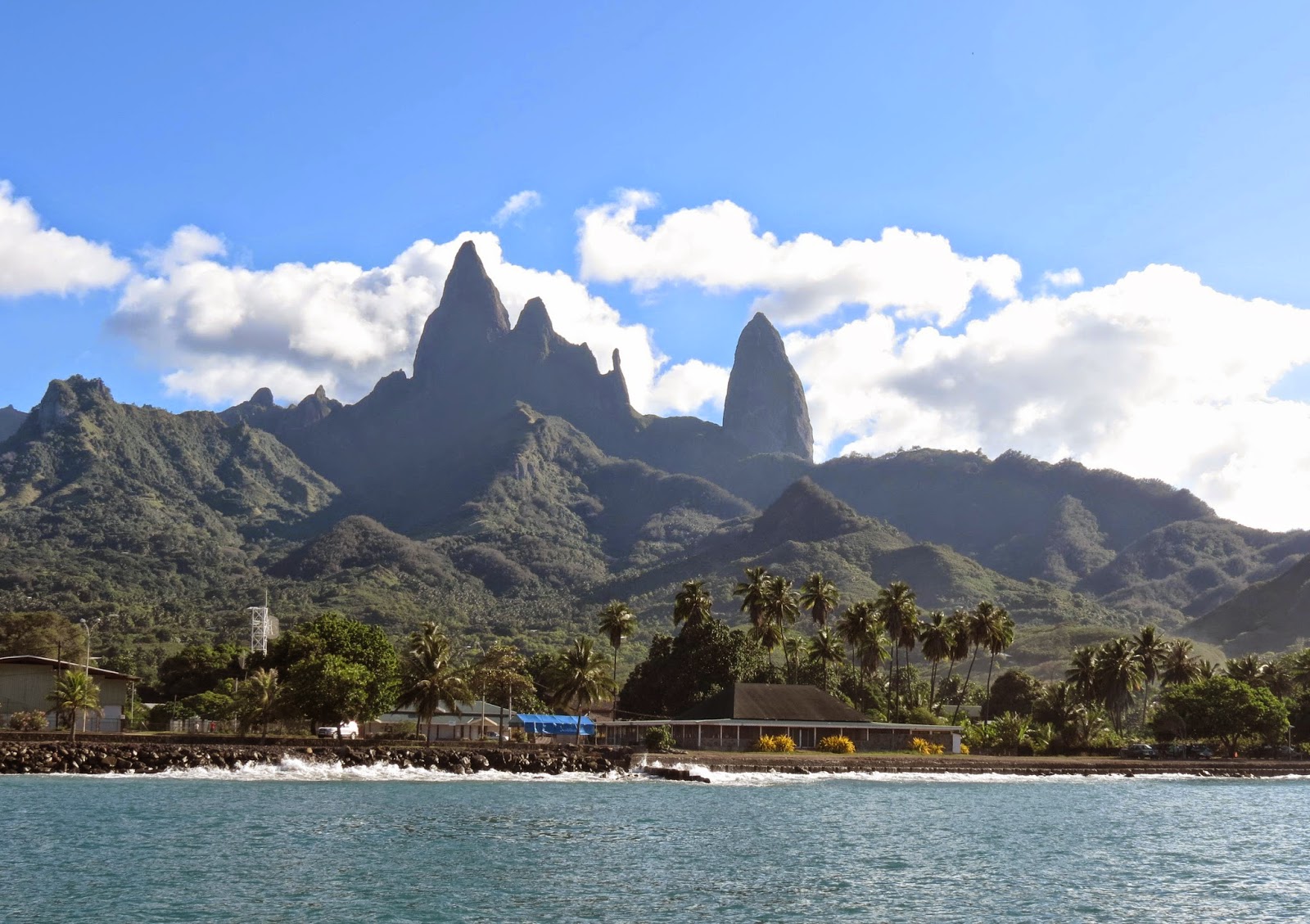
The wind got very light as we approached the islands so we started motoring, the first time in a couple of weeks. Land Ho was about 40 miles out as we say the mountains of Ua Huka. Rather than spend another slow night at sea, we decided to anchor at Ua Huka, an island about 35 miles from Ua Pou our destination. We dropped our anchor here at about 05:30 pm Mar 29 and had a great nights sleep. Just after dawn we upped anchor and continued on to Ua Pou of the Marquesas islands. We ended up motoring all the way in 5 knots of wind. It is Sunday now and we dropped anchor at 04:30pm It is a spectacular anchorage with tall rock pinnacle mountains in the foreground. There was several boats in here with the Arc rally.
The next morning we launched our dingy and rowed to the cement dock by the stairs and found the gendarme to clear into the country. No problem here and a half hour later we were free to explore the island.
Our third day here we were having dinner at the pizza cafe and two Gendarmes came in and told us there was a tsunami warning out due to an earthquake off Chile. and we should move our boat out to sea for a few hours. I knew the shallow basin we were in would not be a good place in even a small tsunami, so we decided to head out. The Tsunami was expected to arrive here between 11:00 and 12:00am midnight. It was said we should stay out until 2am. a real nuisance this time of night. Of course there was a nice 18 knot sailing breeze out there just when we did not need it. So we bounced around in the swells for a few hours. Did a slow beam reach out and then back in. before we left we say some of the locals moving their small boats off the walls and out into the center of the basin. We came back in at 1:30am and I don't think anything happened. Note: We did finish our pizza before we left, very good.
INFO
-Our strategy to get from the Galapagos to the Marquesas had been to ease down to 4 deg South and go straight west and ride the favourable current and winds all the way. But we left in March which can have fickle winds and is not as ideal as April or May to leave. This in Cornells cruising guide, and I guess it was right. So we dropped further South to get better wind but lost the current doing this. This was the first time in trip around the world that we did a long passage not at the optimal time. We took just over 29 days for passage.
-Anchorage at Ua Huka. Dropped anchor in 42ft at 08 55.73S 139 32.02W It is a bit rolly in here, but tolerable. We had a good sleep here. Big surf on beach and we did not go ashore.
-Anchorage at Ua Pou in 22ft at 09 21.49S 140 02.81W good anchorage and holding, not as rolly as other Marquesas anchorages as long as your behing the breakwater.
-Clearing in. We said we only wanted to stay 5 days and then Nuka Hiva a few days and then on to Hawaii. Hoping to avoid the bond hassles. The Gendarme phoned up someone and said Canadians don't have to do the bond but Americans do. That was news to us, maybe it is new, but we were not going to argue. So we filled out a form and were done, no charges.
-There is a water tap on beach and by cement dock, but they say it is not drinking water including taps in peoples houses. There is two taps marked potable war by the school for free drinking water for anyone. But it is a 15 minute walk. The tap on the beach I treat with bleach and put in the tank. The drinking water jugs we carried down to the school or used our small water maker.
-There is a poor selection of fruit and veggies here, but we did get a bunch of apples. Lots of cans of quality baked beans and other canned goods. Found no oats or porrage which we needed. The owner of the pizza cafe across from store speaks good english and he got us a bunch of pampelmous, like a grapefruit. Cant seem to buy them in stores.
-Polynesian Franc is about 80 to a dollar.
We motored off and on for the next 4 days, more on than off. Saw a sea lion and a turtle far out at sea. Another day saw a large humpback whale swimming along nearby. We were doing about 90 miles a day with the help of a 1 to 1.5 knot current. We were motoring very slowly to save fuel and the 4th day did only 64 miles. The 5 day the wind was up finally and we had a good sail all day in a South wind. An Oyster 65 with a professional crew on board flew by us doing 9.5 knots by our AIS. This is the only boat we saw for the rest of the trip except for 4 fishing boas near he middle of voyage.
The next few days we had some good sailing and one day we even did 148 miles with a bit of help from current. But generally there was not quite enough wind for us to get good runs in each day, but at least we were sailing. We do not have enough fuel for much more motoring as we wanted to save some for the last couple hundred miles. A couple of nights we had rain off and on all night and intermittent wind, very annoying, like we were still in the ICTZ. We are about 4 deg South now and headed mostly west. The wind is light all day and the sails bang as the swells twist the boat around in the light winds. I find putting a reef in the main or even 2 reefs is better when there is no wind and the sails are slamming. The reefs flatten the sail and They don't seem to slam as much and the sail still helps stop the boat form rolling.
We have been talking to Mojombo on a daily radio schedule. They are now about 60 miles ahead of us, and they say they are getting some wind down at 5 deg South. We decide to head more South and we picked up some wind after motoring 45 minutes, so shut off engine. Some rain squalls came through and the wind picked up more and then we had a monsoon like downpour for over an hour and then it eased to steady rain. and then the wind was up to 30 knots and a bit more at times. The wind eased to 25 knots a few hours later and it blew like this all night and into next morning along with a rough sea. Mojombo got the same system we got so it was more than a rain squall . All the wind has been South winds, not the SE trades. Good sailing the next few days, wind up and down. Am throwing dead flying fish off the deck every morning now.
We are down at 6 deg South now and sailing in moderate winds more from the SE finally and sailing wing and wing. The nights are often very nice now, we have a full moon and no squalls. Late at night I will lie on cockpit seat with eyes closed listening to the water go by the hull as we are gliding along slowly at 4 knots and boat hardly rocking, it is like a magic carpet taking us to another foreign land. Saw large pod of dolphins come by and swim around our boat for awhile and then do a few spy hoping leaps. Finally they got bored with our slow speed and moved on.
We move our clocks back an hour every 15 degrees of longitude which is one time zone and we will go through 3 time zones getting to the Marquesas. Our favorable current has disappeared as we got further South but at least there is better wind. Our AIS alarm went off last night indicating a collision coarse with something. It was a 160ft Japanese fish boat near by. I adjusted course a bit to go around the back of him, but not too close in case he had a net out. Tried calling him on the radio but no answer. We saw three more of these vessels over the next few days. Two of them had AIS. Our SSB radio was not transmitting properly the last few days, I believe it is the tuner.
Today is our 24 day out at sea and the winds are still a bit too light for good sailing, but we are moving. There is a large number of goose neck barnacles on the hull now. I have never seen so many. They attach to hulls of moving boats. I am sure this growth is slowing us down some, like we need to be going slower. We did 84 miles today. Our day is from 8am to 8am to measure our 24 hour runs. It use to be noon to noon when every one took a noon site with their sextants.
The odd squall comes by but they do not have a lot of wind in them and just a we bit of rain. The wind picked up a couple of days later and we put a reef in the main for the night and part of next day. But this eventually eased again to light winds which seem to be the norm now. It is funny how the moral on the boat goes up and down with the winds. Good winds is good moral. We only have a couple hundred miles to go now, looking forward to some fresh fruit and french baguette. Today we crossed our out bound track that we made to Fata Hiva 4 years ago. We are now Circumnavigators!
The wind got very light as we approached the islands so we started motoring, the first time in a couple of weeks. Land Ho was about 40 miles out as we say the mountains of Ua Huka. Rather than spend another slow night at sea, we decided to anchor at Ua Huka, an island about 35 miles from Ua Pou our destination. We dropped our anchor here at about 05:30 pm Mar 29 and had a great nights sleep. Just after dawn we upped anchor and continued on to Ua Pou of the Marquesas islands. We ended up motoring all the way in 5 knots of wind. It is Sunday now and we dropped anchor at 04:30pm It is a spectacular anchorage with tall rock pinnacle mountains in the foreground. There was several boats in here with the Arc rally.
The next morning we launched our dingy and rowed to the cement dock by the stairs and found the gendarme to clear into the country. No problem here and a half hour later we were free to explore the island.
Our third day here we were having dinner at the pizza cafe and two Gendarmes came in and told us there was a tsunami warning out due to an earthquake off Chile. and we should move our boat out to sea for a few hours. I knew the shallow basin we were in would not be a good place in even a small tsunami, so we decided to head out. The Tsunami was expected to arrive here between 11:00 and 12:00am midnight. It was said we should stay out until 2am. a real nuisance this time of night. Of course there was a nice 18 knot sailing breeze out there just when we did not need it. So we bounced around in the swells for a few hours. Did a slow beam reach out and then back in. before we left we say some of the locals moving their small boats off the walls and out into the center of the basin. We came back in at 1:30am and I don't think anything happened. Note: We did finish our pizza before we left, very good.
INFO
-Our strategy to get from the Galapagos to the Marquesas had been to ease down to 4 deg South and go straight west and ride the favourable current and winds all the way. But we left in March which can have fickle winds and is not as ideal as April or May to leave. This in Cornells cruising guide, and I guess it was right. So we dropped further South to get better wind but lost the current doing this. This was the first time in trip around the world that we did a long passage not at the optimal time. We took just over 29 days for passage.
-Anchorage at Ua Huka. Dropped anchor in 42ft at 08 55.73S 139 32.02W It is a bit rolly in here, but tolerable. We had a good sleep here. Big surf on beach and we did not go ashore.
-Anchorage at Ua Pou in 22ft at 09 21.49S 140 02.81W good anchorage and holding, not as rolly as other Marquesas anchorages as long as your behing the breakwater.
-Clearing in. We said we only wanted to stay 5 days and then Nuka Hiva a few days and then on to Hawaii. Hoping to avoid the bond hassles. The Gendarme phoned up someone and said Canadians don't have to do the bond but Americans do. That was news to us, maybe it is new, but we were not going to argue. So we filled out a form and were done, no charges.
-There is a water tap on beach and by cement dock, but they say it is not drinking water including taps in peoples houses. There is two taps marked potable war by the school for free drinking water for anyone. But it is a 15 minute walk. The tap on the beach I treat with bleach and put in the tank. The drinking water jugs we carried down to the school or used our small water maker.
-There is a poor selection of fruit and veggies here, but we did get a bunch of apples. Lots of cans of quality baked beans and other canned goods. Found no oats or porrage which we needed. The owner of the pizza cafe across from store speaks good english and he got us a bunch of pampelmous, like a grapefruit. Cant seem to buy them in stores.
-Polynesian Franc is about 80 to a dollar.
Friday, February 21, 2014
Messing around in the Galapagos
The Galapagos are made up of many
islands, but just four big ones. Why did
we choose to go to Isabela, the biggest of the islands? We had read that on Isabela you can see everything
here that you can see on the other islands.
Isabela has less people on it, about 1500 population. It is a quiet
laid-back island with no city atmosphere, and has the best anchorage apparently and the
officials are supposedly a bit better to deal with. Also we hope to avoid the ARC rally here..
The anchorage is fairly peaceful, you don't have tour boats roaring
through it constantly. There are tour
boats around but they are off to the side because of the nature of the
anchorage, and you seldom get them through the anchorage, just the small boats
come through occasionally, depending on
the tide height. Isabela island is about
60 miles long and sits right on the Equator and our anchorage is at the South
end of island or about 40 miles South of equator.
The first thing we did here was explore the small town about a 15 minute
walk from our dinghy dock. The dinghy
dock behind the large main dock often has sea lions on it, and on the way in if
the tide is down you can see blue footed boobies and the occasional Penguin. Also you may see a manta ray or a turtle as
well on the way in. The path from dinghy
dock has lots of the black iguana's along it, some up to 3ft long.
A couple days later we took a taxi for $10 up the coastal road to its
end at the 'wall of tears' built by prisoners.
Here there is a short steep hike up to the top of a hill for a great
view. Then we walked the 7 km back to
town, there was a number of short side excursions off the road you could take
to different beaches and lagoons and see birds.
We also saw lots of large land tortoises along the way. We were nice and tired when we got back,
party because of the heat and mostly because our legs had again got out of
shape after 11days at sea. It is nice
and cool near the water but inland it is very hot.
A couple days later after we were feeling a bit fitter, we booked a hike
up a volcano. The hike costs $30 dollars
each which includes the 45 min ride up and a tiny lunch. It is a 16km round trip hike that takes you
up along the slopes of the volcano to to some fantastic views of the huge
crater and then the trail takes you along long lava tubes and caverns created
by the molten lava. The volcano area is
often socked it and gets more rain, so our views were sporadic as the clouds
came and went. We had a bit of light
rain off and on and it was fairly cool out.
We also saw some steam vents that are hot if you put your hands in them. The included lunch was nothing much,
recommend you bring some of your own food and water. It was interesting talking to some of the
land tourists on the hike, some from Equador, Italy, Austria and one Canadian
girl.
Another day I replaced some of the rusty galvanized turnbuckles on our
rigging. I had bought some replacements for $18.00 each just before we left
Panama.
Today we did the "tunnels" snorkelling trip for $70 each.
It is a 45 minute hi-speed boat ride up the coast to an area where the
volcanic lava had flowed into the sea and there is many arches, tunnels and channels that our boat could work its way up. Then the boat tied up to a rock and we walked
around on the arches and rock. We could
see lots of large turtles and fish swimming in the channels. All very impressive. Then we went to a couple
of different snorkelling places. Some people who could dive down saw seahorses.
Lunch again was a laugh, one apple and one tetra pack of juice was lunch.
People were not too happy, we had brought some of our own food so were
okay.
There is no apparent culture on island, it is just a tourist place. Not much money spent on place, the roads are
still mostly unpaved and dusty. There
is now 18 ARC boats here from the world rally.
They came in a few days ago and have plugged up the anchorage and
overwhelmed the place, so much for our peace and quiet. We thought they were just going to the other
2 islands which was one of the reasons we came here.
One day we were rowing in to shore and there was some surf curling in
the shallow waters of low tide. We
watched a sea lion body surfing. He
would swim around and surf the wave, then go around and out and do it again and
again. I guess they like to have fun to.
We rented a couple of nice bikes for $2.00 a hour and did the trip up to
the weeping wall again for some scenic exercise. Came back hot and sweaty.
We will probably stay here another 6 to 8 days, that is until near the
end of February and then head off to the Marquesas 3000 miles away.
INFO
-JC organized a water delivery to the
dock for the 3 yachts now here. We bought 25 gallons for $1.50 every 5 gallons.
There is a huge tank on back of a pickup truck with a hose.
-There is some garbage cans near dinghy
dock that we use. Mention this because I read on one of the sites you have to
keep all your garbage on boat.
-You can also have diesel delivered to
dock. JC said he could get it for $4
a
gallon.
-There is always a few sea lions on the
dinghy dock, but we have never seen them get in the dinghies. They do get on some of the small boats that
never move. One yacht with a swim platform at stern would have a sea lion there
occasionally. The sea lions here are
very small. The sea lions we have back
home are 3 times the size of the ones here.
There are lots of fly's here during the day on the boat, but they don't
bite and they disappear at night. The
small town surprisingly has no paved roads and occasionally you have a dust
cloud around you when a truck goes by.
At least there is not a lot of traffic.
Not sure what they do with all $100 park fee they collect from every
single tourist who comes to the
Galapagos, you see little sign of it being spent here.
After you stop thinking about how you have been robbed of $700 (twice as
much as the next most expensive place in the world) for the right to stay for a
meagre 20 days, you see that the island is a nice quiet pleasant place to stay.
Though it's certainly not in the league of places like Reunion and Rodrigues
islands or a number of other places we have visited.
-
The grocery stores have a lot more produce that we had been lead to
believe, and it comes and goes. The
canned goods selection is very poor, a few canned veggies and few other
things. No baked beans! Also all expensive. Though occasionally you are surprised by some
lower prices. Where we sometimes do
internet I get a juice for a $1.
Thursday, February 20, 2014


Thursday, February 13, 2014
Arriving in the Galapagos Islands - Isabela Island
By 06:45am we had dropped our mooring line and were under way for the Galapagos islands about 1000 miles to the West. Panama city slowly receded on the horizon as we sailed in a light Northly breeze. We decided to spent one night in the Las Perlas islands about 35 miles from Panama city. The wind soon died and we ended up motoring for a few hours, but by lunch the wind was back and we had a good sail the rest of the way.
We anchored of the Isla Contadora and had a pleasant night. Early the next morning, on Jan 31, we were off and motored for awhile until the wind filled in. We had to be careful not to burn all our fuel as we had a long way to go. This passage is known for it's light winds and some people use all their fuel getting in.
The wind slowly increased during the day and we were soon sailing at 5 knots. We saw a humpback whale in the late afternoon a 1/4 mile of our stern. As dark came the wind increased in strength and we soon had a reef in our main, so much for light winds. The wind dropped down to 18 to 20 knots by morning. For being so close to the equator it is very cold, we had to wear our wind breakers and pile jackets during the night. The cold water of the Humboldt current is keeping the air cool
We talked to Mojombo on the HF radio each morning and with Baraka who was still back in Panama. For 3 days we had good sailing in brisk North winds. We passed Malpelo Island 70 miles to the east. This is a small rock owned by Columbia.
This afternoon saw lots of ships, must be crossing a shipping lane. We had seen few ships up to now. By midnight the wind had died and we started the engine and motored well into next day and then sailed at 2 to 3 knots. It went like this for another day, light wind sailing or motoring. Also had a head wind for awhile. We had a big squall come over us, no wind but rained for 4 or 5 hours.
Our engine blower died and I took a half hour to replace it with a spare I had. Feb 5 we got some good sailing though we were hard on the wind to make our course That was it for motoring, we got good wind pretty much the rest of the way. We could barely make our course, but each day it got easier as the wind got around to east a bit more. Some times the wind got quite strong and we would put a reef in the main. Last night had a booby bird sit on our bow pulpit all night. We have a knot to knot and a half of current with us.
With about 75 miles to go we realized that we were short by only a couple of hours to make it that night to our destination. So we had to slow the boat down to get there the next day as this is not a good place to try going into at night. We drifted by Isla Santa Fe for a look see to kill some time. Then wanted to cruise by Academy bay on Santa Cruz island for a look-see, but it was dark by the time we went by in the very light wind.
Feb 10 we drifted in a 1.5 knot current and almost no wind all night and arrived at port Villamil on Isablea about 8:30 am. We followed the chart and then some marker buoys into the anchorage where there was three other yachts. and lots of tour boats. 11 days to the Galapagos, not too bad. Anchorage on Isablea is almost 100 miles farther on than the anchorage on the first island of San Cristobal, so another day of sailing.
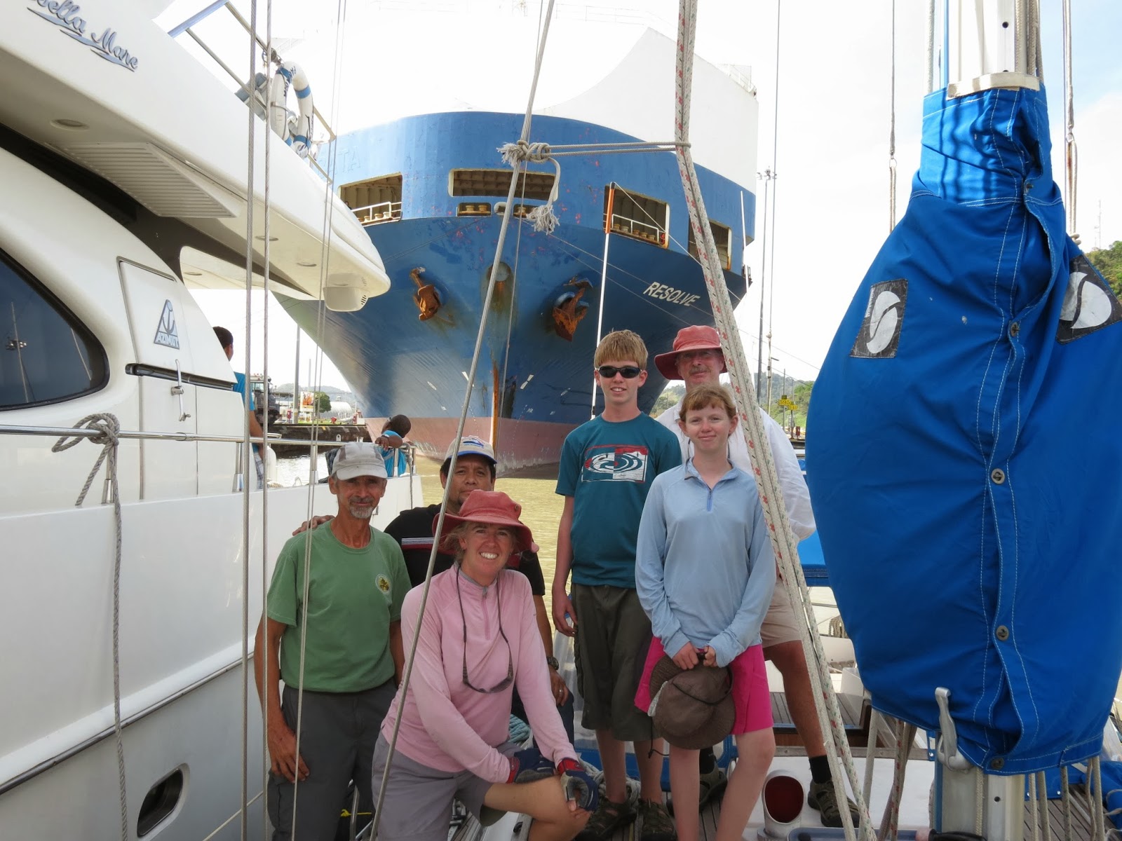
We called up JC on the VHF and we met him on shore by the dinghy dock and he made arrangements for us. A couple hours later 5 people plus him showed up at our boat to do the paper work and take a large amount of money of us. More than any other country in world. The grand total when done is $680 for a boat our size.
The anchorage here is nice and scenic. It is quiet and laid back here on the island. Not many cars, and lots of people using bicycles. JC was good source of info to find everything, can call him on radio anytime for info.
Our second day here we did a trip up to a local farm of several acres. With a truck load of cruisers (6people) it is $5 dollars each for the ride and you can walk through the farm and pick out the fresh from the ground vegetables you want. Very nice! We got onions, tomatoes, pineapple, broccoli, cabbage though they were not very good right now. Also several other veggies available.
Our second day here we did a trip up to a local farm of several acres. With a truck load of cruisers (6people) it is $5 dollars each for the ride and you can walk through the farm and pick out the fresh from the ground vegetables you want. Very nice! We got onions, tomatoes, pineapple, broccoli, cabbage though they were not very good right now. Also several other veggies available.
INFO
-Isla Contadora anchored in 50ft at 08 37.22N 79 02.18W
-Note: leaving Panama we had got a zarpe from the port captain and she gave us some forms to take to immigration. We talked to immigration guy and he wanted copies of everything all over again including visa's which we did not have. To get Visa's is another 100 dollars each and a long day into town and back. We just wanted to leave the country, so since we had our zarpe, we decided to just leave. That we did, just left the next morning. There is no checking on anything here they just want money. Another yacht we know wanted a fumigation certificate for the Galapagoes. So the officals gave him one for 100 dollars, they did not fumigate his boat or even come check it for bugs, they just want money. They charge for everything. Our zarpe cost $40.
- Our passage strategy from Panama was to stay east of 80 degrees in the stronger North winds forecast and ride them down past Malpelo island. These winds we saw on the grib files every day before we left. Then curve around and try to get South as far as possible for a better angle when we got to the south winds. When we got to the South winds, we were hard on the wind to make our coarse to Galapagos. The only slow bit, where we motored, was after the North winds died and until we got to the Steady south winds. As we got closer to the Galapagos the South winds started to get a bit of east in them making it easier to lay a course. Of course this could all be different for someone else, we just planned by what we saw on the gribs and they definitely underreport the wind speed.
Note, we talked to a yacht that got in a week ahead of us but passed Malpelo island further East than we did, so closer to Columbian coast. One night they said there was several boat around them and it looked like there were transferring drugs from boat to boat, no lights, but could see in the moon light. And the next day a panga came up to them with masked people and looked suspicious, they checked the yacht out and were given some beer and they left.
-Getting into final anchorage at port Vilamil is a bit tricky if poor visibility. Here is our waypoints off our track.
1. 00 58.63S 90 58.85W
2. 00 58.057S 90 58.860W now near 1st green buoy
3. 00 58.033S 90 58.280W This should take you between Red and Green buoys
4. 00 57.928S 90 58.011W Up to here water all over 35 feet deep, now gets shallow, 8 to 12 feet near low tide. Could anchor out near this Waypoint ok by big tour boats. But all the yachts went inside to the shallow area, (3 yachts here plus us) not a lot of room in here.
5. Anchored at 00 57.894S 90 57.724W in 9 feet near low tide. Inner anchorage good for 6 or 7 boats then you squeeze in. 12 ARC boats came in a 8 days later and cluttered things up making the place loosing the laid back feel.
- Call JC on VHF 67 and he will do all customs clearance and anything else you want. Has perfect english. He charged us $200 dollars for agent fee (included in the $680 total fees) We asked another yacht what he charged them before he came out and he charged them $200 dollars as well. And same grand total. A 42 foot yacht checked in here as well and paid less than $700. Yacht on San Cristobal seem to be paying $1000. The fee lists are all different too, like they just make it up. Don't bother getting a fumigation certificate in Panama, waste of money.
-The anchorage here is a bit rolly at times from swell that sneaks in. But not too bad. The dinghy dock is just behind the larger dock with local boats tied to it.
-There is a number of small grocery stores with a bit of produce and limited canned goods and usual junk food. Fresh veggies available at farm, (see writeup above) later we notice that if you visit stores every day, things come and go, We got 2 nice cabbages one day and lots of carrots and onions in store. Usually lots of apples.
Tuesday, January 28, 2014
Getting Ready to Leave For The Galapagos
We are still sitting on a mooring at Balboa yacht club, slowly accumulating provisions for our next passage. Our water line is lower than it has ever been as we load the food on board,. There will not be much good provisioning until Hawaii. In Panama City we finally got a new solar panel, a 85 watt with the exact dimensions I wanted.
With the Canal behind us and Tagish back in the Pacific Ocean we feel we are on the home stretch. For the last few months we have often discussed the best route home. There are several choices. The most common used route and the most obvious is to turn right and follow the coast back home. This route is 4100 miles but has often no wind or contrary winds and all the hassles of coastal sailing, it is not a good sailing route.
Another option is to sail from Panama to the Galapagos Islands and from there to Hawaii and then home. But the first 1000 miles is often windless and it is also a very long passage to Hawaii, longer than any we have done.
So the option we have chosen is to sail to the Galapagos for the first leg which is a bit less than 1000 miles. Then sail 3000 miles from Galapagos to Nuka Hiva in the Marquesas for the second leg and then 2000 miles from Nuka Hiva to Hawaii for the third leg and arriving there before mid May. Then leave Hawaii in June for Vancouver about 2700 miles, for a total of 8700 miles or more than double the coastal route. When we arrive in Nuka Hiva we will have officially crossed our out bound track and completed our circumnavigation.
On Sunday we did a pleasant walk up Ancon hill for a great view of the city. There was lots of other walkers going up hill getting some exercise. This hill has a huge flag on top and some microwave towers. Can be seen from our mooring. Panama city waterfront is beautiful and worth a visit, we saw some of it while running our errands.
We are leaving Panama tomorrow and sailing off into the Pacific for the Galapagos. It's about 1000 miles and should take about 9 to 14 days being a light wind passage.
We are leaving Panama tomorrow and sailing off into the Pacific for the Galapagos. It's about 1000 miles and should take about 9 to 14 days being a light wind passage.
INFO
-We leaving for Galapagos Jan 30 2014
-To use the buses in Panama city you need a bus card with money on it. Get card at the main bus terminal at Albrook mall. The huge mall is beside bus terminal. .25 to 50 cents for a bus ride.
Taxies run about $4.00
- It is a great walk up Ancon hill and nice view of city. We walked from Balboa Yacht club, but that was a bit far. You
can take the bus half way and then walk up hill with all the other walkers.
-Went to the port captain and got a zarpe for the Galapagos and he charged $40 and then $10 dollars as they cleared us both in and out, as we never saw any officials when we arrived in Panama city. Panama seems to be one of the most expensive countries to clear in and out off. See Galapagos post next to see what we did in the end.
-Groceries in Panama city are fairly cheap and good selection, though still missing somethings we like. For example not much choice in dried fruit, the same for snack bars, just found granola bars.
No good shopping close by, everything a bus or taxi ride.
Monday, January 27, 2014


Subscribe to:
Posts (Atom)