Next morning we headed to the next bay 6 miles up the coast to get a tad closer to the Similans and a better wind angle for sailing so we could do the distance in daylight hours. It is a nice big bay, not as busy as Patong. We were off at the first bit of daylight the following morning and heading for the Similans 51 miles away. We had a great sail for the first 15 miles and then the wind died and had to motor sail the rest of the way. Last 8 miles a wind from NNW picked up almost heading us but we got enough drive from sails to keep us going decently into the chop. A rain squall came through giving us a good dump of rain with not too much wind. It then rained off and on through out night as well.
We arrived a t 5:15pm with our fingers crossed hoping there would be a mooring buoy available, and yes there were two. The buoys are all full off and on during the day as tour boats come and go and then after 4pm or so they leave except for some live aboard dive boats that take available buoys just before dark.
Next morning we went ashore and had a hike up a good trail to a 350ft high hill with a great view and then explored the tiny island, it had a few bungalows you could rent and a bunch of tents as well set up you could rent. When we rowed back to our boat we found four, 35ft tour boats hanging off the back of our boat! One boat had put a line over my stern cleat and then 3 others rafted up to him, pretty nervy, but they did not seem to be causing a problem as the wind keep them back, so I let them stay, they were gone in a couple of hours. The place is very busy with tour boats of all sizes and they are not suppose to anchor of the beach and there is only a limited number of buoys. Dorothy did some snorkeling as well, trying 3 different spots and no coral at all to speak of, saw a number of fish and a turtle definitely not up to all the hype we heard about islands.
After a couple days we moved to the next island called Koh Similian about 6 miles North. It is another great little island with an incredibly soft sandy beach. Also a nice short little hike up a rocky hill that all the tourists were doing for the great views. Good fish snorkeling and underwater rocks but not much coral
We left after a couple days here but as we got out into the sea a large SE swell headed us and a E wind so we here almost knocked to a stand still so after a bit of that nonsense turned back and returned to our previous mooring. A French catamaran that had left just ahead of us also returned. The forecast for the next day was the same so it was not until the following day that we finally left and had a good sail for the first 15 miles until wind died and motor sailed and then about half way back an E wind came up making it hard to make our course.
We did not arrive until an hour after dark to the same bay we anchored in a week ago. A NE wind which we had going out and is common here would have been nice to come back with but no such luck.
INFO
- Patong Bay anchored in 22ft at 07 53.426N 98 17.092E see previous post.
-Moved boat to other side of Patong Bay in 37ft at 07 54.410 98 17.245
-Next bay 6 miles North, Bang Thao bay, anchored in 29ft at 07 59.352 98 16.842 also at 08 01.504 98 16.970, there is a river you can dinghy up here if tide is up a bit. Nice walking beach. Okay anchorage, a few jet skis. All anchorages on this coast seem to be a bit rolly as fairly open. Great beach to walk on.
- Similian Islands At Koh Miang island took mooring in 105 ft at 08 33.966N 97 38.428E There is 4 or 5 red mooring balls here.
Gets very bouncy here at times, almost to the point you want to leave. It's not bow burying waves, just a constant confused sea and roll and at night had a bit of a S wind come up making it worse. Ball further S might be better. More to do on this island and beach landing much easier. Has a cafe to eat out. Got marginal Internet here, just enough to read a few emails, but not do much else.
- Similian Island 6 miles further North, Koh Similian took ball in 41ft at 8 39.986 97 38.730 Is 5 or 6 mooring balls here. Not nearly as bouncy here as previous island but beach landing in bigger surf. We had lunch at cafe here on beach, was good, and cheap. No Internet but phone service good. Snorkeled lots of places but was just as good right in bay where moored. Snorkel by pass where tour boats enter bay and then other side of bay just up from moorings along rocks. Got hit up for a park fee at this island by a parks dinghy that came by, 400b per person and 100 for boat and good for 5 days and he gave us a receipt ticket.
Thursday, December 29, 2011


Tuesday, December 20, 2011
Chalong Bay to Patong bay 07 54 Deg N
After checking into Thailand we went for a walk to check the locale out. Busy again with tourists, must be their number one business. We found some good stores for grocery shopping and a Home Depot imitation store right down to the orange aprons, and stocked similar. Lots of tour boats take off from here for trips out to the islands. No real beach on this side of Chalong Bay.
We took a taxi up to Rolly Tasker for 300 Baht to get our new mainsail adjusted. As soon as the problem was explained, 4 Thai women attacked the sail and it was finished in 15 minutes, no charge. The sail loft is gigantic and lots of sailboat hardware for sale here in their chandlery.
After 2 nights in Chalong bay we decided that was enough as it is so busy with tour boats, and we needed to get moving to see more sights anyways. Late afternoon we left and had a great sail over to Ko Man or Nai Harn Bay at South end of peninsula about 6 milers away. The two beaches we could see are completely full with chairs and sun umbrellas, and many tourists about. (We soon discovered that all beaches are lined with chairs) A chair costs 100 baht or just over $3.00. This is a very pretty bay and the shops on shore not so crazy as Phi Phi Don Island. It is a pleasant anchorage to spent a few days. We hiked up the hill and out to the point on a trial on the South side of bay for a bit of exercise and a great view. Left the dingy on the smaller beach on South side at its E end, no problems.
We left after 2 nights here to head up to Patong bay, 9 miles to the North. This is a large deep bay that is popular with everyone we read, thought only 3 yachts anchored here. We went ashore and discover this to be the busiest place for tourists we have yet seen and millions of tourist shops, crazy. In the anchorage jet skies buzz around us like annoying flys, and 2 cruise ship sit in the harbour with tenders going to and fro. We are noticing that there are far fewer people that speak english here than in Malaysia. It is hard to ask anybody anything as they only know a few words. We asked six different people where the Carefore supermarket was finally found out it not exist anymore. Did find a Big C super market which is very large.
Took a bus into Phuket town for 25Baht each. Explored town and veggie market. Thai's seem to better off than Indonesians but not as well off as Malaysians it seems. The town was a bit run down. We stopped at the Central Festival mall on the way back, a much more modern mall with lots of phone and electronics stores. We got more time added to our internet dongle, 30hours/ one month for four dollars.
As soon as we arrived back at the boat we moved to the other end of the bay to get away from the heavy boat traffic and jet skiis.
INFO
-Nai Harn Bay or Ko man bay- 6 miles from Chalong bay. Anchored in 48ft at 07 46.431N 98 18.000E It is quite protected in here and not much swell. We liked this anchorage best of the last few we have been in including ones mentioned below, both for boat protection and ambiance .
-Patong Bay 9 miles further. Anchored in 22ft at 07 53.426N 98 17.092E quite rolly at times as the boat sits sideways to swell in NE wind. Dinghy dock in SE corner of bay at floating pontoon on it's South side, not far from where we anchored. Cruise ship tenders constantly going by us, not a great anchorage. But we here because the dinghy dock is handy and secure.
Tons of shops and grocery stores on shore. Major tourist town. Actually quite hard to find anything it is so big. We are glad we did not anchor too close to shore as loud music until late, but we were out far enough it was just a dull thump thump.
Bus into Phuket runs all along the beach front road, says 'Phuket town' on it. Cost 25 baht each. We caught bus a few 100 meters North of dinghy dock where there is a cross street. at 8:50 am, bus drove up the beach road just before 9am.
After coming back from Phuket town, we moved the boat to other side of bay to get away from the rolling and constant boat traffic to cruise ships and also the jet skiis. Anchored in 37 ft at 07 54.410N 98 17.245E.
Note: While in Phuket town we took a taxi over to checkout the Ratanachai Slipway for boat haul out. Lots of room there, only half full. The thing I did not like was because it is a slipway the boat sits on a carriage about 4ft high, so anything you do on hull must be done from a scaffold as boat so high up, making it very difficult to do anything yourself.
Friday, December 16, 2011
Malaysia to Phuket Thailand
Have had no Internet for the last week.
After 20 days at Langkawi it was time to leave for Thailand. We reluctantly returned our air conditioner an hour before we left the marina, coiled up the water hose and power cord and were away by about 10am. We only had about 4 miles to go over to Telaga Harbour were we anchored. ( see bottom of article for cruising info.)
This was just an overnight stop so we could check out with customs to get our clearance document for Thailand and get some diesel as well. We arrived at Telaga just before the customs guys went for lunch so got our paper work done. It turned out when we checked in at Kuah they did not do it correctly, so the guy here just said no bother we will check you in and then out. They seemed to be better organized here and know what they were doing and very helpful and friendly. We were done in 20 minutes.
We then filled our jerry cans at the fuel dock and poured them into the fuel tank through our baja filter. Then late in the afternoon we left the dinghy at the dinghy dock and hiked up the road past where the tram goes up the local mountain for another kilometer and then found the trail up to a waterfall. It was a nice steep uphill hike which we needed, as we would not get much exercise this next week.
If you get your diesel fuel at the gas station rather than the fuel dock, it is quite abit cheaper. The catch is that you are only allowed 20 liters or one jerry can a day. So we did one yesterday and one this morning and got a couple of goodies with the last of our Malaysian money at the store before we headed out to sea for Thailand.
By 9am we were under way and managed to sail only about 8 of the 27 miles to the Butang group of islands in a light NE breeze. We took a mooring ball in the middle of the islands and then Dorothy went for a swim off the boat to try some snorkeling and reported that it was only so-so. I also went for a swim of the back off the boat with a mask and snorkel and scrapped the propeller of accumulated sea life from our 20 day stay in the marina.
The next morning at 8AM before the tour boats come out, we took the boat over to a group of rocks about a mile West and took a mooring and then used the dinghy to go around the rocks and Dorothy snorkeled. There we a lot of tiny jellyfish in the water so Dorothy had put here stinger suit on put she said she could feel them stinging her face. The next day her lower face was swollen and had a rash that persisted for a few days. The snorkeling here was also only so-so probably lots of fish when the tour boat come out and feed them.
That night we took a mooring ball a half mile North of our previous night but found it bouncy here and the rope on the ball was a bit short to pull up at high tide so we moved back to our original ball. I like to lift the ball out of the water so it not bang on hull during night when wind and tide change.
Next day tried some snorkeling where more tour boats go at the S end of Koh Butang. Used a mooring again but again were not impressed with the snorkeling. It is too bouncy to stay here and we ended up back on original mooring for the night.
We left at first light for the Koh Rok group of island which are about 43 miles away. We have been told that once you enter Thailand you have seven days to get to Phuket where you can check into the country properly. If you take much longer they may fine you. It is only about 100 miles due North so it is generous.
As we head out channel to the open sea we get strong NE winds and soon have the 3rd reef in main as I don't like to heel too much with engine running. We were motoring to get out of narrow channel and the wind was on the nose of course. Ounce outside we could bear off onto our course and start sailing. We could just barely make our course without pinching, the spray was flying as we drove hard to windward. Had to keep a bit too much sail up to punch through the close seas. Were now at 2 reefs in main and in a hour had full sail up to keep boat driving. Soon wind was down and we were back to motor sailing but by 11am the wind was up again and we shut the engine off and sailed the rest of the way with the boat heeled well over, smashing to windward, something we have not had for a long time. We found a mooring ball available in the channel between the islands and tied off to it. It was quite bouncy but tolerable in the 16 to 20 knot winds that were blowing. There were several other boats on moorings here as well. We did not snorkel here, though it is suppose to be good, as Dorothys face was still not better. We saw lots of small fish in the clear water around the boat, but the coral so-so. It was a pretty spot to spend the night.
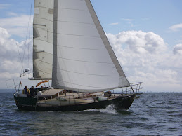
We left about 7am next morning for Koh Phi Phi Le islands 33 miles away and sailed the first 5 miles and motor sailed the rest. As we approached Phi phi group we could see tall cliffs and rock towers promising interesting islands. As we came around the S end of island to our bay on the West side, we were captivated by a spectacular view.
The bay, maybe a quarter mile wide is surrounded by tall cliffs and at head of bay is a beautiful beach. This is where the movie "The Beach" with Leanardo De Caprio was filmed. Unfortunately the whole beach front was filled with small long tail tour boats speed boats and beach full of tourists. There is no resorts here, everyone here came by tour boat or yacht. By 4:30pm the tour boats had all gone home with there clients and the beach was empty. But then several big sunset cruise boats came into bay and sat for an hour to let their guests take pictures and then left and we finally had the bay to ourselves except for 5 other yachts moored in bay. We have found the air temp cooler and cooler at night after we got out of the heat hole at Rebak and seen no more mosquitoes since we left Rebak marina as well.
We went ashore for a walk up and down beach to stretch the legs when we first arrived and were surrounded by young bikini clad women and men. I think we were by far the oldest people on beach. It is a stunning spot and we enjoyed our stay here in spite of the tour boats.
Our last stop before Phuket is Phi Phi Don just 4 miles away.We motored against a stiff breeze to get into the bay at S end and anchored. On the way over we heard on the radio that a yacht had plucked a Thai fishermen out of the water 5 miles from us. With the language barrier the yacht skipper did not know how he ended up in the water or whether there was more than one person.
Phi Phi Don is another beautiful island but it is also about the busiest place for tourists I have ever seen. There is rows of narrow alley ways with hundreds of tiny shops just thrown up. The Tsunami had wiped this place out. A great thing about here is there was no motorised vehicles, Thai's moved there wares about by handcarts and bicycles. The place is just jammed with tourists that come over from Phuket on big ferries. We spent most of the day on shore exploring.
We left early the next morning to sail the 23 miles over to Phuket. It turned into our best sail since Indonesia, 15 knots on the beam all the way and almost no sea, perfect. Lots of yachts and tour boats anchored in Chalong bay. We anchored not too far from customs jetty. (see below) The check in went smoothly and we were free to explore Thailand.
INFO
-Telaga Harbor Dec 8/2011 anchored in 15ft at 06 21.687N 99 40.509E Customs and Port Captain 5 minute walk from dinghy dock which is by fuel dock. Descent food store and prices at the gas station, which also operates fuel dock.
-Butang Islands, Thailand Dec 9 took a mooring ball in 50ft at 06 31.632N 99 16.985E. Supposedly the red or orange mooring balls are okay for us to use. At the coordinates given there is single mooring balls every 300 meters or so along this shore for a total of maybe 6 or 7, did not count them. The next three island groups described below are much more interesting than the Butang group we thought.
-Koh Rok group. Mooring we used was in 15ft at 07 12.985N 99 03.593E There was about 6 moorings here and a few more along the beach by park HQ. Watch as some are in water too shallow for us yachts. Did not go ashore here as heard might have to pay a big fee?? Not really have the time anyways.
-Koh Phi Phi Le Mooring we used is in 70 ft at 07 40.793S 98 45.775E There is about 6 moorings in bay.Two big power yachts anchored in bay. Some swell gets into bay. There is a snack bar up a trail at end of beach. Another trail takes you past washrooms to a super lookout over the back of the island. Trail good for flip flops, 5 min.walk.
-Koh Phi Phi Don Anchored in 57ft at 07 43.700N 98 46.268E by 2 other yachts. Very, Very busy Harbor, with an almost continuous stream of big and small tour boats.
Lots of shops on shore. Tied dinghy with several others at the West side of ferry dock on back of floating barge. We observed that it would be far quieter to have anchored on the West side of island. You would have access to same beach and town, just need a place to put dinghy. We saw several yachts there, but not know where they put there dinghys.
- Ao Chalong bay-Phuket Anchored in 20ft 07 49.105 98 21.435 Left dinghy tied to ramps at end of very long dock with a big pink glass building on it. Can also tie up half way down dock by stairs. Can also take dinghy to beach on right side of dock for a few 100m to right at Phuket Yacht club, can see big letters. Not low tide, mucky.
Customs was at foot of dock just to your right. Took 30 min to check in with Custom, immigration and Port Captain in the one building. They took pictures of both of us so may want everyone there? Found a Tesco about 25 min walk away, up side street and then left at major street down it for 1km and store on your left. Then found better store at shopping villa 15 walk away also as Home Pro store there, a copy of Home Depot, even with the orange aprons.
There is a fuel dock on the long pier near it's outward end, iffy taking boat to it as is just some palm tree stumps lashed together and very busy with tour boats. We took jerry cans and got some diesel and gasoline there. Someone said there was a fuel barge but we never saw it.
-We got a new Sim card at a Seven Eleven store, for $4.00, 1 hr, 1 month for our mobile phone.
Used my old Indonesian dongle for internet that I also used in Malaysia and Indonesia. had a sim card put in it as well for $5.00 for 5 hrs. Later after I tested that it worked, got more time added, 30 hrs for 1 month unlimited data for $4.00 more. Using it for this, speed about as good as Malaysia which surprised us as we read that it was extremely slow for surfing in Thailand, shall see as we go along.
After 20 days at Langkawi it was time to leave for Thailand. We reluctantly returned our air conditioner an hour before we left the marina, coiled up the water hose and power cord and were away by about 10am. We only had about 4 miles to go over to Telaga Harbour were we anchored. ( see bottom of article for cruising info.)
This was just an overnight stop so we could check out with customs to get our clearance document for Thailand and get some diesel as well. We arrived at Telaga just before the customs guys went for lunch so got our paper work done. It turned out when we checked in at Kuah they did not do it correctly, so the guy here just said no bother we will check you in and then out. They seemed to be better organized here and know what they were doing and very helpful and friendly. We were done in 20 minutes.
We then filled our jerry cans at the fuel dock and poured them into the fuel tank through our baja filter. Then late in the afternoon we left the dinghy at the dinghy dock and hiked up the road past where the tram goes up the local mountain for another kilometer and then found the trail up to a waterfall. It was a nice steep uphill hike which we needed, as we would not get much exercise this next week.
If you get your diesel fuel at the gas station rather than the fuel dock, it is quite abit cheaper. The catch is that you are only allowed 20 liters or one jerry can a day. So we did one yesterday and one this morning and got a couple of goodies with the last of our Malaysian money at the store before we headed out to sea for Thailand.
By 9am we were under way and managed to sail only about 8 of the 27 miles to the Butang group of islands in a light NE breeze. We took a mooring ball in the middle of the islands and then Dorothy went for a swim off the boat to try some snorkeling and reported that it was only so-so. I also went for a swim of the back off the boat with a mask and snorkel and scrapped the propeller of accumulated sea life from our 20 day stay in the marina.
The next morning at 8AM before the tour boats come out, we took the boat over to a group of rocks about a mile West and took a mooring and then used the dinghy to go around the rocks and Dorothy snorkeled. There we a lot of tiny jellyfish in the water so Dorothy had put here stinger suit on put she said she could feel them stinging her face. The next day her lower face was swollen and had a rash that persisted for a few days. The snorkeling here was also only so-so probably lots of fish when the tour boat come out and feed them.
That night we took a mooring ball a half mile North of our previous night but found it bouncy here and the rope on the ball was a bit short to pull up at high tide so we moved back to our original ball. I like to lift the ball out of the water so it not bang on hull during night when wind and tide change.
Next day tried some snorkeling where more tour boats go at the S end of Koh Butang. Used a mooring again but again were not impressed with the snorkeling. It is too bouncy to stay here and we ended up back on original mooring for the night.
We left at first light for the Koh Rok group of island which are about 43 miles away. We have been told that once you enter Thailand you have seven days to get to Phuket where you can check into the country properly. If you take much longer they may fine you. It is only about 100 miles due North so it is generous.
As we head out channel to the open sea we get strong NE winds and soon have the 3rd reef in main as I don't like to heel too much with engine running. We were motoring to get out of narrow channel and the wind was on the nose of course. Ounce outside we could bear off onto our course and start sailing. We could just barely make our course without pinching, the spray was flying as we drove hard to windward. Had to keep a bit too much sail up to punch through the close seas. Were now at 2 reefs in main and in a hour had full sail up to keep boat driving. Soon wind was down and we were back to motor sailing but by 11am the wind was up again and we shut the engine off and sailed the rest of the way with the boat heeled well over, smashing to windward, something we have not had for a long time. We found a mooring ball available in the channel between the islands and tied off to it. It was quite bouncy but tolerable in the 16 to 20 knot winds that were blowing. There were several other boats on moorings here as well. We did not snorkel here, though it is suppose to be good, as Dorothys face was still not better. We saw lots of small fish in the clear water around the boat, but the coral so-so. It was a pretty spot to spend the night.
We left about 7am next morning for Koh Phi Phi Le islands 33 miles away and sailed the first 5 miles and motor sailed the rest. As we approached Phi phi group we could see tall cliffs and rock towers promising interesting islands. As we came around the S end of island to our bay on the West side, we were captivated by a spectacular view.
The bay, maybe a quarter mile wide is surrounded by tall cliffs and at head of bay is a beautiful beach. This is where the movie "The Beach" with Leanardo De Caprio was filmed. Unfortunately the whole beach front was filled with small long tail tour boats speed boats and beach full of tourists. There is no resorts here, everyone here came by tour boat or yacht. By 4:30pm the tour boats had all gone home with there clients and the beach was empty. But then several big sunset cruise boats came into bay and sat for an hour to let their guests take pictures and then left and we finally had the bay to ourselves except for 5 other yachts moored in bay. We have found the air temp cooler and cooler at night after we got out of the heat hole at Rebak and seen no more mosquitoes since we left Rebak marina as well.
We went ashore for a walk up and down beach to stretch the legs when we first arrived and were surrounded by young bikini clad women and men. I think we were by far the oldest people on beach. It is a stunning spot and we enjoyed our stay here in spite of the tour boats.
Our last stop before Phuket is Phi Phi Don just 4 miles away.We motored against a stiff breeze to get into the bay at S end and anchored. On the way over we heard on the radio that a yacht had plucked a Thai fishermen out of the water 5 miles from us. With the language barrier the yacht skipper did not know how he ended up in the water or whether there was more than one person.
Phi Phi Don is another beautiful island but it is also about the busiest place for tourists I have ever seen. There is rows of narrow alley ways with hundreds of tiny shops just thrown up. The Tsunami had wiped this place out. A great thing about here is there was no motorised vehicles, Thai's moved there wares about by handcarts and bicycles. The place is just jammed with tourists that come over from Phuket on big ferries. We spent most of the day on shore exploring.
We left early the next morning to sail the 23 miles over to Phuket. It turned into our best sail since Indonesia, 15 knots on the beam all the way and almost no sea, perfect. Lots of yachts and tour boats anchored in Chalong bay. We anchored not too far from customs jetty. (see below) The check in went smoothly and we were free to explore Thailand.
INFO
-Telaga Harbor Dec 8/2011 anchored in 15ft at 06 21.687N 99 40.509E Customs and Port Captain 5 minute walk from dinghy dock which is by fuel dock. Descent food store and prices at the gas station, which also operates fuel dock.
-Butang Islands, Thailand Dec 9 took a mooring ball in 50ft at 06 31.632N 99 16.985E. Supposedly the red or orange mooring balls are okay for us to use. At the coordinates given there is single mooring balls every 300 meters or so along this shore for a total of maybe 6 or 7, did not count them. The next three island groups described below are much more interesting than the Butang group we thought.
-Koh Rok group. Mooring we used was in 15ft at 07 12.985N 99 03.593E There was about 6 moorings here and a few more along the beach by park HQ. Watch as some are in water too shallow for us yachts. Did not go ashore here as heard might have to pay a big fee?? Not really have the time anyways.
-Koh Phi Phi Le Mooring we used is in 70 ft at 07 40.793S 98 45.775E There is about 6 moorings in bay.Two big power yachts anchored in bay. Some swell gets into bay. There is a snack bar up a trail at end of beach. Another trail takes you past washrooms to a super lookout over the back of the island. Trail good for flip flops, 5 min.walk.
-Koh Phi Phi Don Anchored in 57ft at 07 43.700N 98 46.268E by 2 other yachts. Very, Very busy Harbor, with an almost continuous stream of big and small tour boats.
Lots of shops on shore. Tied dinghy with several others at the West side of ferry dock on back of floating barge. We observed that it would be far quieter to have anchored on the West side of island. You would have access to same beach and town, just need a place to put dinghy. We saw several yachts there, but not know where they put there dinghys.
- Ao Chalong bay-Phuket Anchored in 20ft 07 49.105 98 21.435 Left dinghy tied to ramps at end of very long dock with a big pink glass building on it. Can also tie up half way down dock by stairs. Can also take dinghy to beach on right side of dock for a few 100m to right at Phuket Yacht club, can see big letters. Not low tide, mucky.
Customs was at foot of dock just to your right. Took 30 min to check in with Custom, immigration and Port Captain in the one building. They took pictures of both of us so may want everyone there? Found a Tesco about 25 min walk away, up side street and then left at major street down it for 1km and store on your left. Then found better store at shopping villa 15 walk away also as Home Pro store there, a copy of Home Depot, even with the orange aprons.
There is a fuel dock on the long pier near it's outward end, iffy taking boat to it as is just some palm tree stumps lashed together and very busy with tour boats. We took jerry cans and got some diesel and gasoline there. Someone said there was a fuel barge but we never saw it.
-We got a new Sim card at a Seven Eleven store, for $4.00, 1 hr, 1 month for our mobile phone.
Used my old Indonesian dongle for internet that I also used in Malaysia and Indonesia. had a sim card put in it as well for $5.00 for 5 hrs. Later after I tested that it worked, got more time added, 30 hrs for 1 month unlimited data for $4.00 more. Using it for this, speed about as good as Malaysia which surprised us as we read that it was extremely slow for surfing in Thailand, shall see as we go along.
Friday, December 2, 2011
What are our Future Plans? Relaxing at Langkawi and a New Mainsail
What are our future plans over the next year? How do we get home? There are four options and we are at the point where we have to commit ourselves. We can sell the boat, ship the boat, do a circumnavigation or return home by the Pacific Ocean. The Circumnavigation is what I have always wanted to do and Dorothy is into it, so we will contiunue with that even though we now have to take the tougher route down around South Africa with the Red sea being too dangerous because of pirate activity.
Plans always change, but currently we are looking at heading up to Thailand in a week or so and then late February cross the Northern Indian Ocean to Sri Lanka and then down to Mauritius Island and eventually over to South Africa. Will not be mentioning exact dates until after the fact for security reasons.
We have been taking the free ferry over to the main island of Langkawi every couple of days. It is a 15 min ride on a 35 ft speed boat. We rent a car occasionally for 40 rm or about $14. It is a 7 hour rental and no paper work, no insurance bothers. You give the guy the cash and he gives you the keys, He did not even ask our names or to see any ID or drivers license. He has been renting cars to cruisers here for a number of years. (Din 012 402 0827)
With the car we drove over to the highest mountain on the island which has a cement stairway to it's summit, consisting of 4280 stairs. The steps are in good condition but they have not done much work to keep them clean of debris falling on them, there was a number of places where the hand rails where crushed by falling trees. Also two places where you had to climb around a big mess of trees. As we neared the top I could feel something in my sandles and found that small leeches where getting inside and then got squashed and left a bloody mess. I had to remove several on the way down as well. Lots of blood comes when you pull them off as we had no salt. Dorothy was okay with running shoes and socks.
After a bit over an hour we arrived at the top of the stairs with tired knees. We were a bit disappointed as the stairs don't quite go to the top where there is a radio tower and road.
We are also stocking up on stores as it is cheaper here. This is also the best place to get courtesy flags and copy's of charts at the same store.
Also got our new mainsail that we ordered from Rolly Tasker in Phuket Thailand. Our old Lee mainsail was rotting and ripping easily. We were not pleased with how long it lasted. This new one seems better made and was still an excellent price. The sail fits fine except for a minor mistake with the foot of the sail which we will get fixed when we arrive in Phuket. I think it was a result of a misunderstanding in emails. We are pleased with their service, always answered our emails quickly, and efficient delivery of sail to us.
Saturday, November 26, 2011


Friday, November 25, 2011


Sunday, November 20, 2011
R&R in Rebak marina
We have now been in the marina 3 days. It is nice to stay in one place for a bit after moving steadily all the way up from Singapore. Will probably stay here until Dec 12 before moving on to Thailand. The last week has been about as hot as we have every had since leaving Canada.
Yesterday we rented an air conditioner from the boat yard here for 50rm a month (about$18.) and mounted it outside so that it blows in one of the ports into the cabin and I taped a piece of plastic around it. Works great, makes life on board more pleasant. We have been melting at night because there are a lot of mosquito's around at night and we need the bug screens in and the no-see-um netting blocks about 70% of the air flow.
This morning we took the free ferry over to Langkawi. Rebak is on a small island a mile off the West side of the much bigger island, Langkawi. There is nothing at the dock where ferry drops you, but we walked first to the airport about 20 minutes away and looked in the shops there and topped up my Celcom phone and had a Starbucks coffee. Then we walked up to a larger grocery store with veggies. It turned out to be a very good store with everything and it was another 20 minutes further past airport.
Rebak marina is a pleasant enough place to stay. We can use the hotel pool across the way and also a gym on this side is available. Considering it is a small island there is a fair amount of walking you can do, even found a steepish little trail through bush up a hill then down steeply to a beach we can do. This afternoon we were surprised to see huge clouds of white fog descending on us and then realized they were fogging the area to kill mosquitoes. Apparently no malaria on Langkawi. Have a small list of boat chores to do over the next two weeks between outings.
Thursday, November 17, 2011
Arrival in Langkawi Malaysia 06 18deg N
The day before we left Penang we had a second go at hiking up 'Penang hill which has a cable car going to the top. This time we were in a bit better shape from our first attempt and we made it to the top which is 830 Meters and 5km one way. Great views from the top. After checking the prices for taking the cable car down we decided to hike down as well. The knees all did okay, it was great to get some real exercise again.
It was another crack of dawn start to head to Langkawi 58 miles away. A mile out of the marina we saw the first long floating surface net we had seen in a while. Then we soon saw dozens of fish boats. We went through 3 large fleets of fish boats the first 20 miles. Then saw some strange vertical sticks in groups of 10 or 15 sticking straight out of the water and the water was a 100ft deep. I suspect a net was underneath and there was dozens of them for several miles around 5 .49N and 100 .06E. They could be a problem for night sailing as they had no lights. Saw almost no fish boats the last 25 miles.
On the whole we had fast conditions today with a light NE wind and no swell, for good motor sailing, and actually managed to sail 6 or 7 miles. We arrived at our anchorage by 5PM and dropped anchor in 15ft at 06 18.674N 99 50.736E off the town of Kuah. Lots of other yachts around us for a change and big ferry boats running back and forth.
We cleared in with customs first thing in the morning which took all of two minutes, and then looked around the town. Langkawi is a duty free island almost on the Thailand border, so has lots of duty free stores. They are selling brand name chocolates, china and corning ware and liquor. Beer was cheaper than anywhere I had seen before, a can for much less than a dollar. The supermarkets where you buy food were not all that great.
The anchorage where we are now is good though it got a we bit bouncy this afternoon with a wind blowing into the bay and lots of boats running to and fro. There is a nice dinghy dock at head of bay, we just watched where the other dinghys went to see where to go. Supposedly it is 3 rm a day but the guy is hardly ever around to collect it apparently. Tomorrow we will be moving into Rebak Marina about 11 miles away on the West side of Langkawi. It's entance wp is 6 17.445N 99 41.729E and VHF ch 69.
Saturday, November 12, 2011
New!! Search the Blog now
Just found out I can add the search bar you see at top of blog, So now can just type in the name of place you want to see about and there it is. Don't have to search whole blog now.
Also Note: The most rescent posts are often re-edited a few days later with corrections or changes and additions or just trying to fix my bad writing and mis-spellings, especially after a long passage. So have a second look a few days later.
Also Note: The most rescent posts are often re-edited a few days later with corrections or changes and additions or just trying to fix my bad writing and mis-spellings, especially after a long passage. So have a second look a few days later.
Thursday, November 10, 2011
Pangkor to Penang Malaysia 05' 24"deg N lat.
We left Pangkor around 8am to ride ebb tide up through channels. It would be a easy day today up to our next anchorage only 18 miles away. We followed the inside route hugging coast as it was shorter and depths were good except for about 2 seconds when the depth sounder jumped up to about 8 feet deep when it saw something below us that was not on chart.
We anchored behind a small island in 24ft at 04 25.189 100 34.915 using the waypoints someone gave us. It was a bit rolly and got worse as the NW wind picked up and showers started. So the Admiral suggested we go anchor 1/4 mile away right behind the island. We moved and anchored in 28ft at 04 25.191N 100 34.714E. This was much better here, thought when setting the anchor, I felt it skip a couple of times before grabbing. Perhaps the holding here is not quite as good. We had a good night here. Just before dark a 60ft sailboat came in and anchored right behind us, so we were not all alone.
The next morning we left at the crack of dawn and had a 10 knot head wind and large swell against us all day, so it was slow going. There were many fish boats along our coarse but they were easy to avoid and their nets were not a problem as they seemed to be deep in the water.
We did not arrive at our anchorage until almost dark at 7pm and dropped anchor in 25ft at 05 14.904S 100 16.682E at Rimau island. You could easily come in here in the dark, no obstacles and lighthouse on the island. Did 58 mile today, all motor sailing.
Next morning we had a slow start and then did the 7 miles up to the appropriately named "Junk anchorage" on the East coast of Penang Island. We passed through the huge new bridge they are building from the mainland to Penang island, passing between two large pillars where we imagine the center span will be. And then a mile later passed under the older bridge center span with lots of room to spare.
We anchored in 20 ft at 05 24.606S 100 20.506. This is just south of the Tanjong city marina where we leave our dinghy to go explore the city. The marina charges 5rm to leave your dinghy there and they will let you use there showers if you give them a deposit for the key. We did not want to use the marina as apparently there is a noisy night club on edge of marina that plays loud music until 2am also it has no breakwater and can get very bouncy inside. Many of its docks are already broken and boats have broken cleats and mooring lines in there. The water both in the marina and anchorage is full of garbage and there is a number of old work boats anchored around us. Around us is tall apartment buildings and office towers. The island of Penang has a population of about 800,000 people.
In spite of the negative remarks above, we are enjoying our stay here, it is an interesting place and lots to do. We are exploring old George Town, which is a UNESCO World Heritage site. The sidewalks are half descent in this area and interesting old British colonial buildings here. There is also an old fort to explore for 2rm. If you head into the more downtown area, the walking becomes hairy in the busy traffic and extremely poor sidewalks if any at all. I am noticing that the Malays do not walk, you see almost no pedestrian traffic, lots of motorbikes.
There is tons of shopping here if you so desire. There is a Carrefour and "Giant" supermarket and large mall 20 minutes walk away. Can also leave the dinghy at Chews jetty, directly across from anchorage (Just to N of small yellow and red shack on stilts). I drop Dorothy off on the steps then motor dinghy around to back of dock and tie to it. If it's low tide need to be athletic to get in or out of dinghy, a class 5.4 climbing move. There is a cement ledge on some of the dock posts that you can get a toe hold on as you climb up, fun.
Taking dinghy to Chews jetty saves having to pass behind the small, busy car ferry terminal to get to Tanjong marina and it is a shorter walk to the shopping as well.
We also got our Thailand visa's here and while waiting for them we walked from there up to the Botanical gardens and then up a steep jeep trail up the 800M hill called Penang hill. Wow, we have lost all our conditioning. We did not make it to the top as we had to get back to pick up our visa's at 3:30pm and the heat and all the previous walking was too much. Lots of monkeys around. To get Thai Visa, us Canadians needed 2 passport photos, a copy of passport and passports and 110RM each.
We heard the other marina, Jabatan Laut, is full. At the last anchorage we were at we talked to a boat on the VHF it mentioned a new marina, the Straits Quay marina at North end of Penang Island that they stayed at and liked. So we made a reservation for a couple of nights there in a few days.
We moved into the Straits Quay marina this morning. I believe it is the nicest marina we have seen in Malaysia. Actually it is too nice, the area is a bit prissy, guards and gates some of the side streets. It is a totally differant world than downtown Panang. It is a ten minute walk to the Tesco supermarket and some shops and cafe's. Around the marina are a number of expensive places to eat and shop. There is a nice sea wall to walk along and actual proper sidewalks on the roads. And it's only 3rm a meter to stay here. The marina is almost full. We found it very hot here at night as it is in a hole between tall buildings and there are mosquitoes so we had our but screens on. There is also a lot of chatter on the walkway right above from the cafe's and people walking until 11 or 12 pm. The boats with the air conditioning don't notice as they close their boat up and just hear the air con all night.
The approach wp is 05 28.424N 100 19.051E by a buoy. from there head to 05 27.526N 100 18.993E. Then turn hard right which is just before the transit steel poles and head for marina entrance. Head for the clock tower building without the clock, right at entrance.
Transit Poles?? I now realize we misread their vague instructions, they did mention there were leading marks, but I though they were talking about the waypoints. We noticed that if you went to line up the transits, you were not on the line of the two waypoints they sent us. So which is correct? We stayed on the waypoint line as we were already there and depths were ok. We were not sure when to turn until the manager on the breakwater yelled turn hard rite long before we got to the second wp they gave us.. So the waypoint I give is the one we turned on to enter marina. Manager said they dredged the channel 30M wide. and 3M deep. We did not even notice the transit poles until we were fairly close in. Probably best not come in right at a real low tide. We saw depths get down to 9 ft and that was about 3 or 4 feet above zero tide. It is a big open area, would not be surprised if it has silted in some already.
Saturday, November 5, 2011
Pangkor Malaysia 04 12.6 Deg N
We left at the first hint of daylight to take advantage of the ebb tide out of the river. As soon as I started to pull up the anchor it started to rain. We had 3 months without rain in Indonesia and now it seems to be making up for it as we get some rain everyday now.
The wind came up a bit as we left the bay and headed North, and managed to sail 10 of the 30 miles we had to do today. The wind was just off the nose and we sailed close hauled on stbd tack so there was no sea to slow us down. I tried to phone marina at Pangkor to see if there was room and with the language gap successfully booked a room for Tagish in their hotel. I realized this at the end of the call. Found another number and this time called James at +6016 559 2800 and he said there was room until Nov 10 when the Malasia rally gets in. We have been trying to stay ahead of the rally which has 50 boats in it.
We pulled into the marina as it started to rain again around 2pm. We saw lots of fish boats on the way up today and there was lots of black flags near them but not sure what was attached to flags but it did not seem to be something for us to worry about as long as we did not actually hit them.
Internet works here, actually we have had working internet just about anywhere on the coast though a bit slow sometimes. The marina just opened last year and they installed 2 regular toilets and one squat toilet have no toilet paper in them and the shower is in stall with toilets.
We took the short ferry ride over to Pangkor island to look around. Lots of shops there and fruit and veg. Also taxied over to other side of island and did a short but steep hike up to the swinging bridge. There is also a number of good shops about 20 min walk from marina, walk over bridge and turn right.
Approach waypoints for Pangkor marina, Marina Island. It is very shallow to sides. First wp 04 12.767N 100 35.100E second 04 12.708N 100 35.358E third 04 12.728N 100 35.898E and Marina is at 04 12.665N 100 36.125E Note: When we came out on a low tide of 3 ft we saw depths get down to 8 and 9 feet at times, so at a zero tide, may be touching bottom.
Friday, November 4, 2011
Heading North from Port Klang To Berham River Latitude 03 deg 48min N.
After using the free clothes washer ( no dryer) in the women's washroom at Pualau Indah marina, we left for an anchorage about 12 miles away. This was to shorten the next day which would have been 70 miles, too long a day for us to leave and arrive in daylight.
We motored back up our channel and then cut over to the other channel. See below for details and waypoints. This is a busy shipping channel but if you stay to the West side or the, bush side there is no problem. The East bank is mile after mile of docks and ships loading. It was interesting to see the port in action, even had a big cruise ship go by us, we just stayed close to the bush in 20 to 70 feet of water and we were out of the way of ships. Port Klang is the biggest shipping port in Malaysia and seems to handle a lot more ships that Vancouver harbour. There was a few fishermen but they were using fishing rods not nets.
After leaving marina we went into other channel with this waypoint to indicate it, 02 55.029N 101 16.643E. Then anchored at 03 02.504N 101 20.349E in 22ft. Was a peaceful anchorage, Neptune suggested this one to us when we visited with them the previous night.
An hour before daylight we left to do the 59 miles to our next anchorage in the Berham river. It was another day of motoring. Saw many fish boats today, but they are using a different kind of net than used in the South Malacca strait. These nets are towed behind and are deep in the water so do not present a problem to us and so the boats are much easier to avoid.
We got to our entrance waypoint around 5pm (see below for anchorage details) and then motored into bay and up the river against a 1.5 knot current and anchored just around the corner for a quiet night at anchor. Though a number of fish boats went by during the evening. Heard a few rumbles of thunder but no lighting storms yesterday or today.
We anchored in the Berham river in 14ft at 03 50.823 100 49.550. To enter river, here is a set of Waypoints. First 03 48.208N 100 45.347E Second 03 49.048 100 46.375 Third 03 51.013 100 48.908. The second waypoint is at a white/red buoy and you go in a straight line from it to the last waypoint. (exactly down center of bay on chart plotter)We came in near a low tide of 5 ft and never saw less than 14 ft. At the bottom of a zero tide, depths might get down to7 or 8feet. The water gets a bit deeper after turning corner into river and from last waypoint head to anchorage, watching your depths. When we pulled up anchor in morning it was covered in heavy sticky mud, so would probably hold in almost anything.
Thursday, November 3, 2011


Wednesday, November 2, 2011
Kuala Lumpur visit
We did a day trip into the big city today. We got picked up by taxi at the marina for the ride into Port Klang (Den 012 356 9017 for taxi with good english)and costs 50RM. Then took the train from Port Klang to KL Kuala Lumpur. This costs only about 4 RM each. After arriving in the city we got a schedule and caught the local rail to the Petronas twin towers which were the highest buildings in the world until a few years ago. We were disappointed that the free tickets to go up the towers was suspended while they did some maintenance or changes.
We then walked to the tourist info center which gives out very good city maps and they showed us where the shopping was. Then we went exploring.
It is a lively busy dynamic city and we enjoyed ourselves. KL is the capital of Malaysia and has a population of 1.6 million. We did lots of walking around, people watching, and looked in many interesting shops. There is some very high end stores like Harrods, Gucci and all the other very expensive names. There is also lots of cheaper shopping much like Singapore.
Coming back the train was very busy and we had to shove hard to get on train with everyone and were in like sardines and stood for the first half of trip back. The trains all have a ladies only car which I thought funny. We just grabbed the first taxi we saw by train station for the last leg back and that was 40rm. Got back an hour after dark for the end of a great day.
Monday, October 31, 2011
Port Dickson To Port Klang
Left at dawn to do the 45 miles to Port Klang. We have had the worst sailing we have seen since leaving Canada, we have pretty much motored or motor sailed all the way from Singapore, no wind.
There is a steady stream of ships up shipping lane off coast, not many fish boats today.
The Malay coast is not too interesting, suppose to get better further North.
We arrived at the entrance to Pulau Indah Marina around 4:30pm. There was a good current running with us as we approached marina, so we turned and came up into current to come along side outer pontoon and tie up. It took some playing with the throttle to get the speed right in the 2 knot current and get onto the dock without banging things. There is three separate outer pontoons, could squeeze two 40fters on each one. This huge marina is empty except for 4 boats. We had tried to call marina by phone and VHF 61, but no answer. Though someone did greet us to take our dock lines, I guess they saw us approaching. Another yacht said when they came in they were on their own and when they went up to office one guy was sleeping on couch and the other playing a video game. But they are friendly and laid back here.
It is not wise to enter marina until the current is near slack, there is no break water to stop current and apparently if they built one it would silt up marina. It is only $8.00 a day here, very cheap and has showers and power if you need them. Nothing else here in area. You can get a taxi into town for 35 to 50 RP.
There is a small grocery store, no veggies, about 35 minute walk away. Turn right at road and walk for 15 min and then go left and follow this road for about 20 min, go straight on this road, do not take any right or left turns, just go straight and after 20 min get to a intersection, and store is 200 feet to your right on intersecting road.
We had a montster Thunderstorm go by last night and were wondering if we were going to get hit. You could see bolts of lighting going straight down all around us and and huge cracks and then bangs of thunder, and the rain monsooned down on us.
Entrance waypoints to marina: Channel entrance 02 52.352 101 16.183 then 02 52.745 101 16.183 then 02 53.088 101 17.590 and Marina is at 02 54.453N 101 18.691E
I give these points off our track, because I noticed the depth got down to 13 feet at one point, very close to low tide. Not sure if this is where we were suppose to be but this worked for us and there is no channel markers. There was some small ships in here as well which gave us some confidence to enter river. We stayed more to the right side or South side of river as it looked like it would be deeper, generally 18 to 25 feet, low tide, then crossed near the marina, good depths.
Saturday, October 29, 2011
Up Malacca strait to Port Dickson Malaysia
The time has come to leave Puteri harbour and leave friends behind. It was a nice place to stay. We left at 8am and of course had a 1.5 knot current against us as the channel ebbs South and the coast of Malaysia ebbs North, so can't have both. There was no problems with the many ships around as we stayed inshore of the shipping lane. The current was finally with us late in day.
We found that the current changes about 2.5 hours after the tide change on our Navionics chip. There was very little wind all day and when it did blow it was almost on nose. One big Thunder lightning storm went by but no problem. There is a few yachts that get hit every year and lose all their electronics.
By 4:30 PM we had the anchor down. Anchored of Pulau Pisang Island in 9ft at low tide at 1 27.936N 103 16.384E. All night there is sheet lightning on the horizon making for dramatic night scene.
Anchorage was okay got a bit bouncy for an hour or two. Left at first light to do 70 miles to next anchorage. Had current against us until late morning and then we had good going. Today we saw many fish nets. They are about a half mile long and very difficult to see. Usually have a black flag at one end and then small white floats along net and a vertical white float at other end. We ziz zagged around a few and actually went over the top of two during the day as we did not see them in time, but nothing happened
Often there is a small fish boat at one end of net but not always. Should probably stay on edge of ship lane but it is a few miles out.
We got in well after dark and anchored in 33ft at 02 06.233N 102 19.983E. Was okay here. Some people have anchored at 1 50.1N 102 45 4E about 35 miles south if they had bad conditions. The Malacca Strait so far has had very little sea and is surprisingly calm could anchor almost anywhere at night.
Left at dawn again for the 40 miles up to Port Dickson. Current direction changed around noon and then we where often hitting 7 knots and more instead of 3.8 to 4.5 knots. Arrived about 4PM and used approach waypoint of 2 28.45N 101 49.80E then to 2 28.80N 101 50.61E by entrance to Admiral Marina which is easy.
Did not see many fish nets today and shipping no problem, just had to watch for one near Malacca. We paid 50 RP a night here, pretty reasonable. The marina is nice with a free swimming pool and showers and wi fi at bar. The next day we walked part way to town for some exercise about 10 km north and then caught a taxi the rest of way for 10 rp though it is about 20 to 25 to get back. We caught a bus back for 1.3 rp.
In town I finally found a Celcom dealer with good english and who could make my Indonesian modem for USB port work with a new Sim card and get Internet working. Good to bring your laptop with you as I did, as it first did not work and they had to do something to get it working. For one month it is 48 RP. Much cheaper than buying their modem which other dealers try to force. Found some good grocery shopping in the two malls here. Both fairly close to each other and not far from Celcom dealer. The town otherwise is not particularly interesting, just a town.
We will probably leave in a day or two for port Klang.
Monday, October 24, 2011
Singapore and our first week in Malaysia
Puteri Harbour marina turned out to be a nicer place than we thought and very well protected. Nicer than Danga bay we thought after a speed boat trip up there a bit later. We found a few boats we know in our marina which was nice. Shadow Trader gave us the scoop on the area, buses and shopping and Mojombo told us the ins and out of going to Singapore.
We took the free shuttle into the night market the 2nd day there and then another free shuttle up to a big mall not too far away. I got a broken tooth that needed fixing. Puteri front office suggested a local dentist. I went in without an appointment and had to wait a few hours and then went in and found it was a old office and equipment you would find in the 1950's. He drilled about around the tooth and filled it, no x-rays or freezing. Though it did not hurt. When it came time for the bill I was a bit worried, but all's they asked for was 50rp or about $16.00, super.
We did a bit of cycling in the area as the roads in this area have no traffic as they are in the middle of building a city here and have just done the roads and started a few toweres, so no one is living here yet except us. The walking is great as well, fantastic after Indonesia with it's lack of sidewalks and narrow busy roads and if there was sidewalks they had 2 foot holes in them or motorbikes parked on them or people selling their wares on them.
Today just got back from a day trip into Singapore. It is an exciting place and would keep any shopaholic happy for months. We bought some electronic toys I wanted and a couple of small items for the boat and just explored the city and waterfront, well worth the trip in. It took about 2 hours to get right into town from Puteri , 2 buses and the train and through Malaysian customs and Singapore customs each way.
We are thinking of leaving Puteri Harbour in 2 or 3 days and start heading north and seeing some of Malaysia and Thailand.
Wednesday, October 19, 2011
Enjoying Belitong and on to Singapore
The four days we spent in Belitung flew by. We enjoying a couple of free tours of the island put on by the local government. Part of one tour was to the local schools where we talked to the students and they could ask us questions in minimal English.
On Belitung we had our biggest welcome anywhere in Indonesia. We joined up with the rally for this island and the locals went all out. They put on lots of performances for us and greeted us everywhere we went with big smiles and 'hello mister'. We had our pictures taken with dozens of young people who would walk up and ask to have their picture taken with us. They had vans available to drive us into the nearby town for shopping. They supplied a driver and guide and the vehicle for $10. great deal. We just told the guide what we wanted and they found the correct store for us, even a store with a rat trap. That story coming up.
We had a Canadian thanksgiving party on the Canadian yacht Cop-out with all the Canadian yachts in anchorage.
We left Belitong late in the morning to do a 125 mile overnight passage to the NE corner of Bangka Island. After motoring for the first two hours we had a nice sail for all but the last 40 miles. We crossed two busy shipping lanes in the day and a big fleet of fish boats at night.
We dropped anchor late in morning in 19ft at 01 30.627S 105 52.478E. It was a pretty spot with a nice beach that we took a walk on. Not sure how legal that was as we were officially checked out of Indonesia and suppose to leave directly. No Internet here, but tons of room for many boats.
The next morning we left at 7:30 am for Kentar 115 miles away. Had mostly good sailing and got to Kentar near dawn and decided to keep going another 26 miles to Mesanak island which is anchorage #85 in book. We arrived mid afternoon at waypoint recommended in book and found it very bouncy and windy with the E wind we had so decided to go on to the Asundra group about six miles away. This turned out to be a great anchorage, well sheltered. We dropped the hook in 25 ft at 00 28.466N 104 26.382E There is a village on stilts nearby and we even got some Internet here.
We left at first light to go between Bintan and Batam Islands, up Selau Riau Channel. After motoring for an hour we sailed for a few hours and then back to motoring as we got up the channel. A large T storm and heavy rain squall grazed us and we had rain for 2 hours but avoided the worst of the lighting. These storms are now becoming daily as we get into the storm season. We found a good anchorage on the East coast of Batam about 10 miles South of Nongsa point marina. Anchored at 01 03.571N 104 09.516E in 40ft. was a quiet anchorage but not very pretty with the ugly shipping port on other side of channel. We could have anchored a half mile south in the bay but a big tug and barge were messing around there so we moved up a bit to the waypoints I gave above.
Left at 2:30am for the Singapore area, a big day today. We had hoped to spend a few days at Raffles marina in Singapore but it was full. Instead our destination now is Puteri Harbour marina just across the channel from Singapore, in Malaysia and 5 miles further up the channel than Raffles.
We had to motor pretty well all the way. As we headed along the North coast of Indonesia we had a 2 knot push with the current . We stayed on this side (South side of channel) until near Buffalo rock and crossed here to the Singapore side.
Our Ais on the chart planner was going mad. This is the busiest shipping area in the world. The chartplotter would lockup every hour or so as it got overloaded with all the hundreds of targets. I heard several other Raymarine plotters had same problem on other boats. There was not too much traffic on the Indonesian side but now as we lined up to do a 90 degree crossing of the shipping channels we could see a steady line of ships. Supposedly they average about 1 every 12 minutes. We motored to edge of channel and then waited 15 minutes for two big ships to go buy and then saw a larger gap and gunned the engine and crossed the east bound channel and then stopped again for a few minutes and shot across the next channel to arrive safely on the Singapore side. We could see the high rises of the big city near by.
We then motored along the shore out of the shipping lanes, dodging the occasional ferry or work boat. The shore here was lined with hundreds of fuel storage tanks and ship loading cranes and also piles of dirt as they filled in more of the ocean to reclaim more land.
After we turned the corner to head North up the channel we left all the ships behind and and had a easy trip up the channel. We called Puteri Marina as we neared the bridge over the channel. No answer from them, we tried 4 or 5 times over the next hour and finally got them and they said they were ready for us. There was a two knot current against us up this channel.
We soon arrived at the entrance waypoint to the marina I got off google earth. 1 24.929N 103 39.750E and it was bang on.
We were greeted at the dock by a couple of line handlers and were soon tied up. Welcome to Malaysia they said and to come up to the office when ready for customs clearance. At the office they did the preliminary clearance and then drove us down to the customs office in town and while we sat in a chair they took care of everything. The customs and immigration people did not say a thing to us. All was down in 10 minutes, easy, no hassle, what a difference from Indonesia.


Sunday, October 16, 2011


Subscribe to:
Posts (Atom)